Wald (Allgäu)
Jump to navigation
Jump to search
Wald | |
|---|---|
 General view of Wald | |
_COA.svg) Coat of arms | |
Location of Wald (Allgäu) within Ostallgäu district 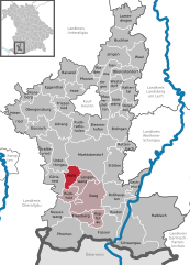 | |
 Wald  Wald | |
| Coordinates: 47°43′N 10°33′E / 47.717°N 10.550°E | |
| Country | Germany |
| State | Bavaria |
| Admin. region | Schwaben |
| District | Ostallgäu |
| Government | |
| • Mayor (2020–26) | Johanna Purschke[1] |
| Area | |
| • Total | 17.97 km2 (6.94 sq mi) |
| Elevation | 800 m (2,600 ft) |
| Population (2022-12-31)[2] | |
| • Total | 1,175 |
| • Density | 65/km2 (170/sq mi) |
| Time zone | UTC+01:00 (CET) |
| • Summer (DST) | UTC+02:00 (CEST) |
| Postal codes | 87616 |
| Dialling codes | 09463 |
| Vehicle registration | OAL |
| Website | www.wald-allgaeu.de |
Wald (German pronunciation: [valt] ) is a municipality in the district of Ostallgäu in Bavaria in Germany.
The village Wald is located in the Allgäu region. The municipality of Wald belongs to the administrative community Seeg and is located in the administrative district of Bavarian Swabia.
The state-recognized recreational resort Wald includes many surrounding hamlets: Barnstein, Bergers, Birngschwend, Geigers, Gemmels, houses, Herring, Hofen, Holzmanns, Kaltenbrunn, Kaufmanns, Kippach, Klosterhof, Neupolz, Öbele, Ofen, Stechele, Wetzlers, Wies, Wimberg.
Sights
-
 Weiher (ponds) of Wald
 -
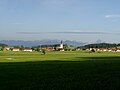
 Wald from the air from the southeast
 -
 Wald from northwest
 -
 Wertachschlucht near Wald
 -
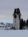 Wald - Church tower after fire, January 2012
 -
 Wald at night, December 2012


External links
Wikimedia Commons has media related to Wald (Allgäu).
- "Wald: History of the coat-of-arms" (in German). Haus der Bayerischen Geschichte.
- Wald (Allgäu): Official statistics compiled by the Bavarian State Office of Statistics (LfStat) (PDF; 1,05 MB)
References
- ^ Liste der ersten Bürgermeister/Oberbürgermeister in kreisangehörigen Gemeinden, Bayerisches Landesamt für Statistik, 15 July 2021.
- ^ Genesis Online-Datenbank des Bayerischen Landesamtes für Statistik Tabelle 12411-003r Fortschreibung des Bevölkerungsstandes: Gemeinden, Stichtag (Einwohnerzahlen auf Grundlage des Zensus 2011) (Hilfe dazu).
Towns and municipalities in Ostallgäu | ||
|---|---|---|
|  | |
| International | |
|---|---|
| National | |
This Ostallgäu location article is a stub. You can help Wikipedia by expanding it. |
Categories:
- Pages using gadget WikiMiniAtlas
- Pages using the Phonos extension
- Articles with short description
- Short description matches Wikidata
- Coordinates on Wikidata
- Municipalities in Bavaria
- Pages with German IPA
- Pages including recorded pronunciations
- Commons category link from Wikidata
- Articles containing German-language text
- CS1 German-language sources (de)
- Articles with VIAF identifiers
- Articles with GND identifiers
- Ostallgäu
- All stub articles
- Swabia (Bavaria) geography stubs