Umiken
Jump to navigation
Jump to search
You can help expand this article with text translated from the corresponding article in German. (February 2009) Click [show] for important translation instructions.
|
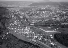
Umiken | |
|---|---|
 | |
 Coat of arms | |
Location of Umiken  | |
 Umiken  Umiken | |
| Coordinates: 47°29′N 8°12′E / 47.483°N 8.200°E | |
| Country | Switzerland |
| Canton | Aargau |
| District | Brugg |
| Area | |
| • Total | 0.8 km2 (0.3 sq mi) |
| Elevation | 355 m (1,165 ft) |
| Population (December 2006) | |
| • Total | 1,066 |
| • Density | 1,300/km2 (3,500/sq mi) |
| Time zone | UTC+01:00 (Central European Time) |
| • Summer (DST) | UTC+02:00 (Central European Summer Time) |
| Postal code(s) | 5222 |
| SFOS number | 4118 |
| ISO 3166 code | CH-AG |
| Surrounded by | Brugg, Riniken, Unterbözberg, Villnachern |
| Website | www SFSO statistics |
Umiken was a municipality in the district of Brugg in the canton of Aargau in Switzerland. On 1 January 2010 the municipality of Umiken merged into Brugg.[1]
Economy
In 2000[update] there was a total of 525 workers who lived in the municipality. Of these, 472 or about 89.9% of the residents worked outside Umiken while 45 people commuted into the municipality for work. There were a total of 98 jobs (of at least 6 hours per week) in the municipality.[2]
References
- ^ Amtliches Gemeindeverzeichnis der Schweiz, Mutationsmeldungen 2009 / Répertoire officiel des communes de Suisse, Mutations 2009 / Elenco ufficiale dei Comuni della Svizzera, Mutazione 2009 (PDF) (Report). Federal Statistical Office. 2009. 3169. Archived from the original (PDF) on 18 November 2010. Retrieved 6 March 2010.
- ^ Statistical Department of Canton Aargau-Bereich 11 Verkehr und Nachrichtenwesen (in German) accessed 21 January 2010
Wikimedia Commons has media related to Umiken.
| International | |
|---|---|
| National | |
| Other | |
This Aargau location article is a stub. You can help Wikipedia by expanding it. |
Categories:
- Pages using gadget WikiMiniAtlas
- Articles with German-language sources (de)
- Geography articles needing translation from German Wikipedia
- Articles with short description
- Short description is different from Wikidata
- Infobox mapframe without OSM relation ID on Wikidata
- Coordinates on Wikidata
- Articles containing potentially dated statements from 2000
- All articles containing potentially dated statements
- Commons category link is on Wikidata
- Articles with VIAF identifiers
- Articles with WorldCat Entities identifiers
- Articles with GND identifiers
- Articles with HDS identifiers
- Former municipalities of Aargau
- Populated places disestablished in 2010
- All stub articles
- Switzerland geography stubs
- Pages using the Kartographer extension