Stolec, West Pomeranian Voivodeship
Jump to navigation
Jump to search
Stolec | |
|---|---|
Village | |
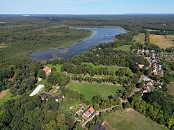
 Aerial view of Stolec | |
| Coordinates: 53°33′27″N 14°18′52″E / 53.55750°N 14.31444°E | |
| Country | |
| Voivodeship | West Pomeranian |
| County | Police |
| Gmina | Dobra |
| Population (approx.) | |
| • Total | 210 |
| Time zone | UTC+1 (CET) |
| • Summer (DST) | UTC+2 (CEST) |
| Vehicle registration | ZPL |
Stolec ([ˈstɔlɛt͡s]; translation: throne, reigning chair) is a village in the administrative district of Gmina Dobra, within Police County, West Pomeranian Voivodeship, in north-western Poland,[1] close to the German border. It lies approximately 10 kilometres (6 mi) north-west of Dobra, 17 km (11 mi) west of Police, and 24 km (15 mi) north-west of the regional capital Szczecin.
The village has an approximate population of 210.
References
