Stašov (Beroun District)
Jump to navigation
Jump to search
Stašov | |
|---|---|
 Municipal office | |
 Flag  Coat of arms | |
 Stašov Location in the Czech Republic | |
| Coordinates: 49°53′0″N 13°57′27″E / 49.88333°N 13.95750°E | |
| Country | |
| Region | Central Bohemian |
| District | Beroun |
| First mentioned | 1085 |
| Area | |
| • Total | 2.33 km2 (0.90 sq mi) |
| Elevation | 293 m (961 ft) |
| Population (2023-01-01)[1] | |
| • Total | 471 |
| • Density | 200/km2 (520/sq mi) |
| Time zone | UTC+1 (CET) |
| • Summer (DST) | UTC+2 (CEST) |
| Postal code | 267 51 |
| Website | www |
Stašov is a municipality and village in Beroun District in the Central Bohemian Region of the Czech Republic. It has about 500 inhabitants.
Demographics
| Year | Pop. | ±% |
|---|---|---|
| 1869 | 553 | — |
| 1880 | 539 | −2.5% |
| 1890 | 534 | −0.9% |
| 1900 | 572 | +7.1% |
| 1910 | 539 | −5.8% |
| 1921 | 544 | +0.9% |
| 1930 | 484 | −11.0% |
| 1950 | 360 | −25.6% |
| 1961 | 412 | +14.4% |
| 1970 | 378 | −8.3% |
| 1980 | 370 | −2.1% |
| 1991 | 309 | −16.5% |
| 2001 | 346 | +12.0% |
| 2011 | 412 | +19.1% |
| 2021 | 455 | +10.4% |
| Source: Censuses[2][3] | ||
Transport
Stašov is located on the railway line Plzeň–Beroun.[4]
Gallery
-
 A street in Stašov
 -
 Centre of Stašov
 -
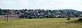 View from the north


References
- ^ "Population of Municipalities – 1 January 2023". Czech Statistical Office. 2023-05-23.
- ^ "Historický lexikon obcí České republiky 1869–2011 – Okres Beroun" (in Czech). Czech Statistical Office. 2015-12-21. pp. 9–10.
- ^ "Population Census 2021: Population by sex". Public Database. Czech Statistical Office. 2021-03-27.
- ^ "Detail stanice Stašov" (in Czech). České dráhy. Retrieved 2024-01-29.
External links
Wikimedia Commons has media related to Stašov (Beroun District).
| Authority control databases: National |
|---|
This Central Bohemian Region location article is a stub. You can help Wikipedia by expanding it. |
Categories:
- Pages using gadget WikiMiniAtlas
- CS1 Czech-language sources (cs)
- Articles with short description
- Short description is different from Wikidata
- Coordinates on Wikidata
- Commons category link is on Wikidata
- Official website different in Wikidata and Wikipedia
- Articles with NKC identifiers
- Villages in the Beroun District
- All stub articles
- Central Bohemian Region geography stubs