Simonson Brook (New Jersey)
| Simonson Brook | |
|---|---|
 Simonson Brook crossing Canal Road, near its mouth at the Millstone River | |
 Map of Simonson Brook | |
| Location | |
| Country | United States |
| Physical characteristics | |
| Source | |
| • coordinates | 40°24′58″N 74°35′29″W / 40.41611°N 74.59139°W |
| Mouth | |
• coordinates | 40°26′21″N 74°37′3″W / 40.43917°N 74.61750°W |
• elevation | 36 ft (11 m) |
| Basin features | |
| Progression | Millstone River, Raritan River, Atlantic Ocean |
Simonson Brook, also known as Sunonson Brook,[1] is a tributary of the Millstone River in southern Franklin Park, Somerset County, New Jersey in the United States.
Course
Simonson Brook starts at 40°24′58″N 74°35′29″W / 40.41611°N 74.59139°W,[1] in southwestern Franklin Park near Route 27. It has several tributaries draining the area near Route 27. It runs through two housing developments then runs into the woods and flows near Bunker Hill Road, passing through the Bunker Hill Environmental Center and the Griggstown Native Grassland Preserve. It then crosses Canal Road and drains into the Millstone River at 40°26′21″N 74°37′3″W / 40.43917°N 74.61750°W.[1]
Simonson Brook is smaller than its fellow brooks, the Ten Mile Run and the Six Mile Run. Many of its stream beds are dry in summer.
Accessibility
Simonson Brook can be accessed by trails in the Griggstown Native Grassland Preserve, part of the Ten Mile Run Greenway. It also crosses several roads, such as Barbieri Court and Ridings Parkway. It is easily accessible at Canal Road.
Animal life
Simonson Brook has several slow spots which are home to frogs. It is characterized by deep pools in some tributaries which hold many fish.
Terrain
This stream is very rocky near its mouth, with broken slate covering the streambed. Occasional deep pools exist on the streambed. It is fed by periodic springs, making it dry up very easily when it is not raining. Fish have a difficult time living in the stream because it dries up often.
Sister tributaries
- Beden Brook
- Bear Brook
- Cranbury Brook
- Devils Brook
- Harrys Brook
- Heathcote Brook
- Indian Run Brook
- Little Bear Brook
- Millstone Brook
- Peace Brook
- Rocky Brook
- Royce Brook
- Six Mile Run
- Stony Brook
- Ten Mile Run
- Van Horn Brook
Gallery
-
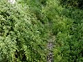 A branch of the Simonson Brook at Ridings Parkway, a dry bed
 -
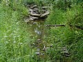
 A branch of the Simonson Brook at Ridings Parkway, a deep pool containing many fish
 -
 Simonson Brook at Morrison Ave, a dry bed
 -
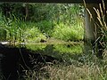
 Simonson Brook at Morrison Ave, a small stream flowing through wetlands
 -
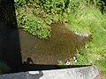
 Simonson Brook at Barbieri Court, under a pipe
 -
 Simonson Brook at Barbieri Court, a small pool where fish live
 -
 Simonson Brook at Barbieri Court, the drainage of the pool
 -
 Simonson Brook running through the Bunker Hill Environmental Center
 -
 Simonson Brook running through the Bunker Hill Environmental Center
 -
 Simonson Brook at Canal Road, facing upstream
 -
 Simonson Brook at Canal Road, facing downstream


See also
References
- ^ a b c "USGS GNIS - Simonson Brook". USGS. Retrieved 18 June 2010.