Sarasara, Uttar Pradesh
Jump to navigation
Jump to search
Sarasara | |
|---|---|
Village | |
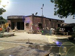
 House in Sarasara | |
| Coordinates: 25°48′N 82°25′E / 25.80°N 82.41°E | |
| Country | India |
| State | Uttar Pradesh |
| District | Jaunpur District |
| Tehsil | Badlapur |
| Elevation | 82 m (269 ft) |
| Population (2011) | |
| • Total | 841 |
| Languages | |
| • Official | Hindi |
| Time zone | UTC+5:30 (IST) |
| PIN | 222141 |
Sarasara is a village in Badlapur, Jaunpur district, Uttar Pradesh, India.
Geography
Sarasara is located at 25°48′N 82°25′E / 25.80°N 82.41°E.[1]
It has an average elevation of 82 metres. It has been assigned 222141 pincode by Indian postal services.[2]
Demographics
As of the 2011 Indian census, Sarsara had a population of 841.[3]
References
Categories:
- Pages using gadget WikiMiniAtlas
- Use dmy dates from January 2019
- Use Indian English from January 2019
- All Wikipedia articles written in Indian English
- Articles with short description
- Short description is different from Wikidata
- Coordinates on Wikidata
- Villages in Jaunpur district
- All stub articles
- Jaunpur district geography stubs
