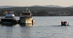
Porat, Croatia
Jump to navigation
Jump to search
This article relies largely or entirely on a single source. (August 2023) |
Porat | |
|---|---|
Village | |
 View of Porat | |
| Coordinates: 45°07′17″N 14°29′39″E / 45.12145°N 14.49408°E | |
| Country | |
| County | |
| Municipality | Malinska-Dubašnica |
| Area | |
| • Total | 4.4 km2 (1.7 sq mi) |
| Population (2021)[2] | |
| • Total | 181 |
| • Density | 41/km2 (110/sq mi) |
| Time zone | UTC+1 (CET) |
| • Summer (DST) | UTC+2 (CEST) |

Porat is a small harbor village on the west coast of the Croatian island of Krk. Located approximately 3 km to the west of Malinska, it is part of the Malinska-Dubašnica municipality. As of 2021, it had 181 inhabitants.[2] The village has a harbor providing access to the Kvarner Bay. A Franciscan monastery dedicated to Mary Magdalene is located in Porat, dating back to the late 15th century.[3][4]
References
- ^ Register of spatial units of the State Geodetic Administration of the Republic of Croatia. Wikidata Q119585703.
- ^ a b "Population by Age and Sex, by Settlements" (xlsx). Census of Population, Households and Dwellings in 2021. Zagreb: Croatian Bureau of Statistics. 2022.
- ^ "Franciscan monastery - Porat". Island of Krk Cultural Heritage. Retrieved 2023-08-14.
- ^ "Monastery of St. Mary Magdalene in Porat". Krk Island Tourist Info. Retrieved 2023-08-14.
External links
![]() Media related to Porat, Malinska-Dubašnica at Wikimedia Commons
Media related to Porat, Malinska-Dubašnica at Wikimedia Commons
Categories:
- Pages using gadget WikiMiniAtlas
- Articles needing additional references from August 2023
- All articles needing additional references
- Articles with short description
- Short description is different from Wikidata
- Coordinates on Wikidata
- Commons category link is on Wikidata
- Krk
- Populated places in Primorje-Gorski Kotar County
- All stub articles
- Primorje-Gorski Kotar County geography stubs

