Manslagt
Jump to navigation
Jump to search
Manslagt | |
|---|---|
_IMG_6638.jpg) | |
 Coat of arms | |
Location of Manslagt  | |
 Manslagt  Manslagt | |
| Coordinates: 53°27′28″N 7°03′43″E / 53.45769°N 7.06199°E | |
| Country | Germany |
| State | Lower Saxony |
| District | Aurich |
| Municipality | Krummhörn |
| Area | |
| • Metro | 8.65 km2 (3.34 sq mi) |
| Elevation | 1 m (3 ft) |
| Population | |
| • Metro | 410 |
| Time zone | UTC+01:00 (CET) |
| • Summer (DST) | UTC+02:00 (CEST) |
| Postal codes | 26736 |
| Dialling codes | 04923 |
Manslagt is a village in the region of East Frisia, in Lower Saxony, Germany. It is part of the municipality of Krummhörn. The village is located between Pilsum and Groothusen.
Manslagt was historically located on an island in the former Bay of Sielmönken and was built on a warft. It was first mentioned around the 11th century.[1] The Church of Manslagt dates from around 1400.[2]
Gallery
-
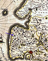 Location of Manslagt on a map by Ubbo Emmius, 1600
 -
 Houses in Manslagt
 -
 Former school, now kindergarten
 -
 Bronze model of Manslagt
.jpg)


Notable people
- Klaus Immer (1924–2022), politician
References
- ^ "Manslagt". Wierden en terpen (in Dutch). Retrieved 17 October 2023.
- ^ "Evangelische-Reformierte Kirche Manslagt". Krummhörn Greetsiel (in German). Retrieved 17 October 2023.
External links
![]() Media related to Manslagt at Wikimedia Commons
Media related to Manslagt at Wikimedia Commons
Categories:
- CS1 Dutch-language sources (nl)
- CS1 German-language sources (de)
- Articles with short description
- Short description is different from Wikidata
- Infobox mapframe without OSM relation ID on Wikidata
- Coordinates on Wikidata
- Commons category link is on Wikidata
- Krummhörn
- Villages in Lower Saxony
- Towns and villages in East Frisia
- Pages using the Kartographer extension