Lucky Peak Lake
Jump to navigation
Jump to search
| Lucky Peak Reservoir | |
|---|---|
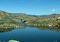
 Lucky Peak Reservoir in April 2010 | |
 Lucky Peak Reservoir  Lucky Peak Reservoir | |
| Location | Ada / Boise / Elmore counties, Idaho, United States |
| Coordinates | 43°31′31″N 116°2′36″W / 43.52528°N 116.04333°W |
| Type | reservoir |
| Primary inflows | Boise River |
| Primary outflows | Boise River |
| Catchment area | 2,680 sq mi (6,940 km2)[1] |
| Basin countries | United States |
| Built | 1955, Lucky Peak Dam |
| Surface area | 2,820 acres (11.4 km2)[1] |
| Water volume | 307,000 acre⋅ft (0.379 km3)[1] |
| Surface elevation | 3,050 ft (930 m) AMSL |
Lucky Peak Reservoir (also known as Lucky Peak Lake[2]) is a reservoir on the Boise River in the U.S. state of Idaho. It is located mainly in Ada County, extending into Boise County and Elmore County. It was created in 1955 with the construction of Lucky Peak Dam.[1] Lucky Peak State Park surrounds part of the lake.
Gallery
-
 Lucky Peak Lake from Idaho highway 21
 -
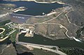 Lucky Peak Lake and Dam
 -
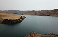 Lucky Peak Lake in December 2018


See also
References
- ^ a b c d Lucky Peak Dam Archived 2011-07-16 at the Wayback Machine, NPDP Dam Directory
- ^ U.S. Geological Survey Geographic Names Information System: Lucky Peak Lake
Municipalities and communities of Ada County, Idaho, United States | ||
|---|---|---|
| Cities |  | |
| CDPs | ||
| Unincorporated community | ||
| Footnotes | ‡This populated place also has portions in an adjacent county or counties | |
This Ada County, Idaho state location article is a stub. You can help Wikipedia by expanding it. |
This Boise County, Idaho state location article is a stub. You can help Wikipedia by expanding it. |
This Elmore County, Idaho state location article is a stub. You can help Wikipedia by expanding it. |
Categories:
- Webarchive template wayback links
- Articles with short description
- Short description matches Wikidata
- Coordinates on Wikidata
- Articles using infobox body of water without alt
- Articles using infobox body of water without image bathymetry
- Ada County, Idaho
- Articles with VIAF identifiers
- Lakes of Ada County, Idaho
- Lakes of Boise County, Idaho
- Lakes of Elmore County, Idaho
- Buildings and structures in Ada County, Idaho
- Buildings and structures in Boise County, Idaho
- Buildings and structures in Elmore County, Idaho
- Reservoirs in Idaho
- All stub articles
- Ada County, Idaho geography stubs
- Boise County, Idaho geography stubs
- Elmore County, Idaho geography stubs