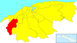
La Lisa
Jump to navigation
Jump to search
La Lisa | |
|---|---|
 | |
 Location of La Lisa in Havana | |
| Coordinates: 23°01′29″N 82°27′47″W / 23.02472°N 82.46306°W | |
| Country | |
| Province | |
| Wards (Consejos Populares) | Alturas de La Lisa, Arroyo Arenas, Balcón Arimao, El Cano-Valle Grande-Bello 26 y Morado, Punta Brava, San Agustín, Versalles-Coronela |
| Government | |
| • President | Yoamel Acosta Morales |
| Area | |
| • Total | 37.5 km2 (14.5 sq mi) |
| Population (2022)[2] | |
| • Total | 147,415 |
| • Density | 3,900/km2 (10,000/sq mi) |
| Time zone | UTC-5 (EST) |
| Area code | +53-7 |
La Lisa (Spanish pronunciation: [la ˈlisa]) is one of the 15 municipalities or boroughs (municipios in Spanish) in the city of Havana, Cuba.
Overview
It has 7 neighbourhoods:
- Alturas de La Lisa
- Arroyo Arenas
- Balcón Arimao
- El Cano-Valle Grande-Bello 26 y Morado
- Punta Brava
- San Agustín
- Versalles-Coronela.
It can be generally thought of as a semi-rural municipality.[citation needed]
References
- ^ Statoids (July 2003). "Municipios of Cuba". Retrieved 2007-10-06.
- ^ "Cuba: Administrative Division (Provinces and Municipalities) - Population Statistics, Charts and Map". www.citypopulation.de. Retrieved 2024-02-03.
External links
 Media related to La Lisa at Wikimedia Commons
Categories:
- Articles with short description
- Short description is different from Wikidata
- Coordinates on Wikidata
- Pages with Spanish IPA
- All articles with unsourced statements
- Articles with unsourced statements from January 2011
- Commons category link from Wikidata
- Municipalities of Havana
- All stub articles
- Cuba geography stubs
