Komorowo, Ostrów Mazowiecka County
Jump to navigation
Jump to search
Komorowo | |
|---|---|
Village | |
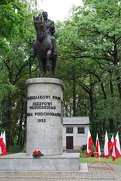
 Józef Piłsudski monument in Komorowo | |
| Coordinates: 52°50′N 21°51′E / 52.833°N 21.850°E | |
| Country | |
| Voivodeship | Masovian |
| County | Ostrów Mazowiecka |
| Gmina | Ostrów Mazowiecka |
| Population | |
| • Total | 2,000 |
| Time zone | UTC+1 (CET) |
| • Summer (DST) | UTC+2 (CEST) |
| Vehicle registration | WOR |
| Highways | |
| Voivodeship roads | |
Komorowo [kɔmɔˈrɔvɔ] is a village in the administrative district of Gmina Ostrów Mazowiecka, within Ostrów Mazowiecka County, Masovian Voivodeship, in east-central Poland.[1] It lies approximately 5 kilometres (3 mi) north-west of Ostrów Mazowiecka and 90 km (56 mi) north-east of Warsaw.
History
In 1827, Komorowo had a population of 185, which by the 1880s grew to 385.[2]
In the interbellum, barracks of the Polish 18th Light Artillery Regiment were located in Komorowo.
Following the joint German-Soviet invasion of Poland, which started World War II in September 1939, the village was occupied by Germany. In 1941–1943, the Germans operated the Stalag 333 prisoner-of-war camp in the pre-war barracks.[3]
References
- ^ "Central Statistical Office (GUS) - TERYT (National Register of Territorial Land Apportionment Journal)" (in Polish). 2008-06-01.
- ^ Słownik geograficzny Królestwa Polskiego i innych krajów słowiańskich, Tom IV (in Polish). Warsaw. 1883. p. 313.
{{cite book}}: CS1 maint: location missing publisher (link) - ^ Megargee, Geoffrey P.; Overmans, Rüdiger; Vogt, Wolfgang (2022). The United States Holocaust Memorial Museum Encyclopedia of Camps and Ghettos 1933–1945. Volume IV. Indiana University Press, United States Holocaust Memorial Museum. pp. 328–329. ISBN 978-0-253-06089-1.
Categories:
- Pages using gadget WikiMiniAtlas
- CS1 Polish-language sources (pl)
- CS1 maint: location missing publisher
- Articles with short description
- Short description is different from Wikidata
- Coordinates on Wikidata
- Articles with VIAF identifiers
- Articles with GND identifiers
- Articles with J9U identifiers
- Articles with LCCN identifiers
- Villages in Ostrów Mazowiecka County
- All stub articles
- Ostrów Mazowiecka County geography stubs
