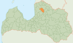
Kocēni Municipality
Jump to navigation
Jump to search
Kocēni Municipality
Kocēnu novads | |
|---|---|
 | |
| Country | |
| Formed | 2009 |
| Dissolved | 2021 |
| Centre | Kocēni |
| Government | |
| • Chairman | Jānis Olmanis (NA) |
| Area | |
| • Total | 498.87 km2 (192.61 sq mi) |
| • Land | 487.58 km2 (188.26 sq mi) |
| • Water | 11.29 km2 (4.36 sq mi) |
| Population (2021)[2] | |
| • Total | 5,776 |
| • Density | 12/km2 (30/sq mi) |
| Website | www |
Kocēni Municipality (Latvian: Kocēnu novads) is a former municipality in Vidzeme, Latvia. The municipality was formed in 2009 by merging Bērzaine Parish, Dikļi Parish, Kocēni Parish, Vaidava Parish and Zilākalns Parish; the administrative centre being Kocēni. Until 28 January 2010 the name of municipality was Valmiera Municipality (Valmieras novads).[3]
On 1 July 2021, Kocēni Municipality ceased to exist and its territory was merged into Valmiera Municipality.[4]
See also
References
- ^ Error: Unable to display the reference properly. See the documentation for details.
- ^ Error: Unable to display the reference properly. See the documentation for details.
- ^ “Grozījumi Administratīvo teritoriju un apdzīvoto vietu likumā”
- ^ [1] Law on Administrative Territories and Populated Areas
57°31′13″N 25°20′17″E / 57.52028°N 25.33806°E
Categories:
- Module:Wd reference errors
- Pages using gadget WikiMiniAtlas
- Articles with short description
- Short description is different from Wikidata
- Pages using infobox settlement with no coordinates
- Articles containing Latvian-language text
- Articles with LNB identifiers
- Coordinates on Wikidata
- Kocēni Municipality
- Former municipalities of Latvia
- All stub articles
- Vidzeme geography stubs

