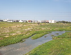
Khasa River
Jump to navigation
Jump to search
| Khasa River | |
|---|---|
 Khasa River in the south of Kirkuk city | |
| Native name | نهر خاصة (Arabic) |
| Location | |
| Country | Iraq,Kirkuk Governorate |
| Physical characteristics | |
| Mouth | |
• coordinates | 34°55′N 44°05′E / 34.917°N 44.083°E |
The Khasa River (Arabic: نهر خاصة, Kurdish: ڕووباری/چەمی خاسە) is a river which runs through the City of Kirkuk in northern Iraq.[1], as happened in the 1950s. The river has a symbolic value to the city's inhabitants. It is one of the tributaries of the Tigris River.
Source
References
- ^ "The Role of Urban Agriculture in Kirkuk, Iraq" (PDF). Urban Agriculture Magazin. January 2009. p. 25.