Ken Lockwood Gorge Bridge
Ken Lockwood Gorge Bridge | |
|---|---|
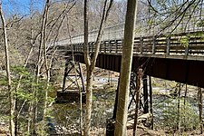
 View looking northwest | |
| Coordinates | 40°41′51.2″N 74°52′20.5″W / 40.697556°N 74.872361°W |
| Carries | Columbia Trail |
| Crosses | South Branch Raritan River |
| Locale | Ken Lockwood Gorge Lebanon Township, New Jersey |
| Characteristics | |
| Total length | 250 feet (76 m) |
| History | |
| Opened | 1891 |
| Location | |
 | |
The Ken Lockwood Gorge Bridge is a steel plate girder bridge built for the High Bridge Branch of the Central Railroad of New Jersey (CNJ) to cross the South Branch Raritan River in Ken Lockwood Gorge of Hunterdon County, New Jersey.[1] It is now open for pedestrian traffic on the Columbia Trail, a rail trail that starts in High Bridge.[2][3]
History
The first bridge constructed here was a wooden Howe truss bridge. On April 18, 1885, an iron ore train drawn by a Baldwin locomotive (#112), named Columbia, fell into the river when the center and southern spans collapsed. Temporary repairs were then made to the bridge.[4]
In 1891, the current 250-foot (76 m) long steel bridge was built to replace the previous wooden bridge. In 1931, it was strengthened to carry heavier loads.[4] The last passenger service on the railroad was in 1935 and the last freight service in 1976.[2]
Gallery
-
 View looking west
 -
 View looking northeast
 -
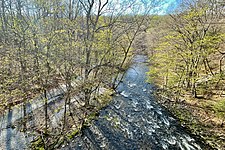 View from the bridge of the South Branch Raritan River gorge


See also
References
- ^ "Columbia Trail - Lockwood Gorge Bridge". HistoricBridges.org.
- ^ a b Hunterdon County, Division of Parks & Recreation. "Columbia Trail, Trail Map and Guide" (PDF). Hunterdon County, New Jersey.
- ^ Helbing, Mike. "Hunterdon Rail Trails: Station To Station". Skylands Visitor.
- ^ a b County of Hunterdon - Department of Parks and Recreation. "The Gorge Bridge Train Wreck. The High Bridge Branch of the Central Railroad of New Jersey". Historical Marker Database.
External links
 Media related to Ken Lockwood Gorge Bridge at Wikimedia Commons
- Articles with short description
- Short description is different from Wikidata
- Coordinates on Wikidata
- Infobox mapframe without OSM relation ID on Wikidata
- Commons category link from Wikidata
- Lebanon Township, New Jersey
- Bridges in Hunterdon County, New Jersey
- Bridges completed in 1891
- 1891 establishments in New Jersey
- Railroad bridges in New Jersey
- Pedestrian bridges in New Jersey
- Steel bridges in the United States
- Plate girder bridges in the United States
- Rail trail bridges in the United States
- Bridges over the Raritan River
- Pages using the Kartographer extension