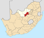
Ikageng, North West
Jump to navigation
Jump to search
Ikageng | |
|---|---|
| Coordinates: 26°42′12″S 27°01′40″E / 26.7034°S 27.0279°E | |
| Country | South Africa |
| Province | North West |
| District | Dr Kenneth Kaunda |
| Municipality | JB Marks |
| Area | |
| • Total | 17.71 km2 (6.84 sq mi) |
| Population (2011)[1] | |
| • Total | 87,701 |
| • Density | 5,000/km2 (13,000/sq mi) |
| Racial makeup (2011) | |
| • Black African | 98.0% |
| • Coloured | 1.2% |
| • Indian/Asian | 0.2% |
| • White | 0.2% |
| • Other | 0.3% |
| First languages (2011) | |
| • Tswana | 58.5% |
| • Sotho | 14.8% |
| • Xhosa | 13.9% |
| • English | 3.0% |
| • Other | 9.8% |
| Time zone | UTC+2 (SAST) |
| Postal code (street) | 2539 |
| PO box | 2539 |
Ikageng is a town in Dr Kenneth Kaunda District Municipality in the North West province of South Africa.
It is a Township bordering Potchefstroom. The name is Setswana and means ‘we built for ourselves’.[2]
References
- ^ a b c d "Main Place Ikageng". Census 2011.
- ^ "Dictionary of Southern African Place Names (Public Domain)". Human Science Research Council. p. 220.
Categories:
- Pages using gadget WikiMiniAtlas
- Use dmy dates from April 2022
- Articles with short description
- Short description is different from Wikidata
- Coordinates on Wikidata
- Populated places in the JB Marks Local Municipality
- Townships in North West (South African province)
- All stub articles
- North West (South Africa) geography stubs


