Ibthorpe
Jump to navigation
Jump to search

Ibthorpe is a village in Hampshire, England.[1] Ibthorpe is in the civil parish of Hurstbourne Tarrant.[2]
Name
Ibthorpe is named after "Ibbaprop" which means, "Ibba's second settlement".[3]
The Hamlet
Most houses are situated around a central horseshoe-shaped road, with some extending toward neighbouring Hurstbourne Tarrant.
-
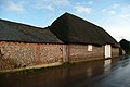 Thatched barn
 -
 Ibthorpe House
 -
 Ibthorpe radio tower


References
- ^ Ordnance Survey: Landranger map sheet 185 Winchester & Basingstoke (Andover & Romsey) (Map). Ordnance Survey. 2013. ISBN 9780319228845.
- ^ "Ordnance Survey Election Maps". www.ordnancesurvey.co.uk. Ordnance Survey. Retrieved 3 April 2016.
- ^ "Village design statement" (PDF). TVBC.
External links
![]() Media related to Ibthorpe at Wikimedia Commons
Media related to Ibthorpe at Wikimedia Commons
This Hampshire location article is a stub. You can help Wikipedia by expanding it. |
Categories:
- Pages using gadget WikiMiniAtlas
- EngvarB from December 2023
- Use dmy dates from October 2019
- Use British English from April 2016
- Articles with short description
- Short description is different from Wikidata
- Articles with OS grid coordinates
- Coordinates on Wikidata
- Commons category link is on Wikidata
- Villages in Hampshire
- All stub articles
- Hampshire geography stubs