Hsarat
Jump to navigation
Jump to search
Hsarat
حصارات | |
|---|---|
| Coordinates: 34°10′N 35°41′E / 34.167°N 35.683°E | |
| Country | |
| Governorate | Keserwan-Jbeil |
| District | Byblos |
| Highest elevation | 641 m (2,103 ft) |
| Lowest elevation | 534 m (1,752 ft) |
| Time zone | UTC+2 (EET) |
| • Summer (DST) | UTC+3 (EEST) |
| Dialing code | +961 09735... |
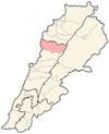
Hsarat (Arabic: حصارات) (also spelled Hisarat, Hasrat, Hsarate, Ḩaşrāt, Hsârâte, Hsarale or Ḩişārāt) is a village in the Byblos District of the Keserwan-Jbeil Governorate, Lebanon. Its inhabitants are predominantly Maronite Catholics.[1]
References
- ^ "Elections municipales et ikhtiariah au Mont-Liban" (PDF). Localiban. Localiban. 2010. p. 19. Archived from the original (pdf) on 2015-07-24. Retrieved 2016-02-12.

