Hrádek (Klatovy District)
Jump to navigation
Jump to search
Hrádek | |
|---|---|
.jpg) View from the southeast | |
 Flag  Coat of arms | |
 Hrádek Location in the Czech Republic | |
| Coordinates: 49°15′49″N 13°29′43″E / 49.26361°N 13.49528°E | |
| Country | |
| Region | Plzeň |
| District | Klatovy |
| First mentioned | 1298 |
| Area | |
| • Total | 36.90 km2 (14.25 sq mi) |
| Elevation | 485 m (1,591 ft) |
| Population (2023-01-01)[1] | |
| • Total | 1,357 |
| • Density | 37/km2 (95/sq mi) |
| Time zone | UTC+1 (CET) |
| • Summer (DST) | UTC+2 (CEST) |
| Postal codes | 342 01 |
| Website | www |
Hrádek is a municipality and village in Klatovy District in the Plzeň Region of the Czech Republic. It has about 1,400 inhabitants.
Hrádek lies approximately 22 kilometres (14 mi) south-east of Klatovy, 55 km (34 mi) south of Plzeň, and 114 km (71 mi) south-west of Prague.
Administrative parts
The villages of Čejkovy, Čermná, Kašovice, Odolenov, Tedražice and Zbynice are administrative parts of Hrádek.
Demographics
| Year | Pop. | ±% |
|---|---|---|
| 1869 | 2,724 | — |
| 1880 | 2,614 | −4.0% |
| 1890 | 2,772 | +6.0% |
| 1900 | 2,624 | −5.3% |
| 1910 | 2,567 | −2.2% |
| 1921 | 2,556 | −0.4% |
| 1930 | 2,468 | −3.4% |
| 1950 | 1,906 | −22.8% |
| 1961 | 1,901 | −0.3% |
| 1970 | 1,678 | −11.7% |
| 1980 | 1,451 | −13.5% |
| 1991 | 1,331 | −8.3% |
| 2001 | 1,327 | −0.3% |
| 2011 | 1,360 | +2.5% |
| 2021 | 1,307 | −3.9% |
| Source: Censuses[2][3] | ||
Gallery
-
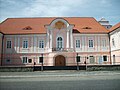 Hrádek Castle
 -
 Area in front of the castle
 -
 Church of Saint Lawrence


References
- ^ "Population of Municipalities – 1 January 2023". Czech Statistical Office. 2023-05-23.
- ^ "Historický lexikon obcí České republiky 1869–2011 – Okres Klatovy" (in Czech). Czech Statistical Office. 2015-12-21. pp. 9–10.
- ^ "Population Census 2021: Population by sex". Public Database. Czech Statistical Office. 2021-03-27.
External links
Wikimedia Commons has media related to Hrádek (Klatovy District).
| International | |
|---|---|
| National | |
This Plzeň Region location article is a stub. You can help Wikipedia by expanding it. |
Categories:
- CS1 Czech-language sources (cs)
- Articles with short description
- Short description is different from Wikidata
- Coordinates on Wikidata
- Commons category link is on Wikidata
- Official website different in Wikidata and Wikipedia
- Articles with VIAF identifiers
- Articles with NKC identifiers
- Villages in Klatovy District
- Prácheňsko
- All stub articles
- Plzeň Region geography stubs