Hochries
Jump to navigation
Jump to search
This article has multiple issues. Please help improve it or discuss these issues on the talk page. (Learn how and when to remove these template messages)
|
| Hochries | |
|---|---|
| Highest point | |
| Elevation | 1,569 m (5,148 ft) |
| Geography | |
| Location | Bavaria, Germany |
Hochries is a mountain in Bavaria, Germany. It is 1569 m high,[1] and is located in the north-western part of the Chiemgauer Alpen. The summit can be reached by cable car from Grainbach. Starting from the village, a chairlift takes you to the middle station at 920 m above sea level. From there, a cable car leads to the summit.[2]
-
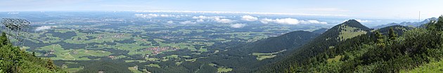 View from Hochries direction north
 -
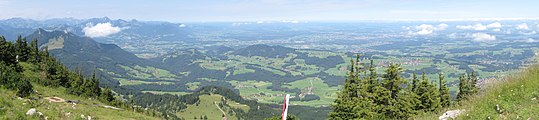 northwest
 -
 south
south


References
- ^ "Hochries - Peakbagger.com". www.peakbagger.com. Retrieved 2022-11-29.
- ^ "Ski lifts Hochries – Samerberg - cable cars Hochries – Samerberg - lifts Hochries – Samerberg". www.skiresort.info. Retrieved 2022-11-29.
Wikimedia Commons has media related to Hochries.
47°45′N 12°15′E / 47.750°N 12.250°E
This Rosenheim district location article is a stub. You can help Wikipedia by expanding it. |
Categories:
- Articles needing additional references from February 2016
- All articles needing additional references
- Geography articles needing translation from German Wikipedia
- Articles with multiple maintenance issues
- No local image but image on Wikidata
- Commons category link from Wikidata
- Coordinates on Wikidata
- Mountains of Bavaria
- Chiemgau Alps
- Mountains of the Alps
- Rosenheim (district)
- All stub articles
- Upper Bavaria geography stubs