Hieronimowo
Jump to navigation
Jump to search
Hieronimowo | |
|---|---|
Village | |
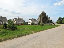
 Houses by an unpaved road in Hieronimowo | |
| Coordinates: 52°59′54″N 23°33′21″E / 52.99833°N 23.55583°E | |
| Country | |
| Voivodeship | Podlaskie |
| County | Białystok |
| Gmina | Michałowo |
Hieronimowo [xjɛrɔniˈmɔvɔ] is a village in the administrative district of Gmina Michałowo, within Białystok County, Podlaskie Voivodeship, in north-eastern Poland, close to the border with Belarus.[1]
References
