Grabfeld, Thuringia
Jump to navigation
Jump to search
Grabfeld | |
|---|---|
 Coat of arms | |
Location of Grabfeld within Schmalkalden-Meiningen district 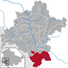 | |
 Grabfeld  Grabfeld | |
| Coordinates: 50°27′N 10°26′E / 50.450°N 10.433°E | |
| Country | Germany |
| State | Thuringia |
| District | Schmalkalden-Meiningen |
| Subdivisions | 13 |
| Area | |
| • Total | 121.08 km2 (46.75 sq mi) |
| Elevation | 360 m (1,180 ft) |
| Population (2022-12-31)[1] | |
| • Total | 5,582 |
| • Density | 46/km2 (120/sq mi) |
| Time zone | UTC+01:00 (CET) |
| • Summer (DST) | UTC+02:00 (CEST) |
| Postal codes | 98631 |
| Dialling codes | 036944, 036947 |
| Vehicle registration | SM |
| Website | www |

Grabfeld is a municipality in the district Schmalkalden-Meiningen, in Thuringia, Germany.
Grabfeld was established as a municipality on December 1, 2007 by combining the former municipalities of Behrungen, Berkach, Bibra, Exdorf, Jüchsen, Nordheim, Queienfeld, Rentwertshausen, Schwickershausen and Wolfmannshausen, replacing the former Verwaltungsgemeinschaft of the same name. It was joined by the former municipality Bauerbach in January 2012, and by Wölfershausen in January 2019.
History
Within the German Empire (1871–1918), the territory of the present-day municipality of Grabfeld was part of the Duchy of Saxe-Meiningen.
References
| International | |
|---|---|
| National | |
| Geographic | |
This Schmalkalden-Meiningen location article is a stub. You can help Wikipedia by expanding it. |
Categories:
- CS1 German-language sources (de)
- Articles with short description
- Short description is different from Wikidata
- Coordinates on Wikidata
- Municipalities in Thuringia
- Articles with VIAF identifiers
- Articles with GND identifiers
- Articles with MusicBrainz area identifiers
- Former Verwaltungsgemeinschaften in Thuringia
- Schmalkalden-Meiningen
- Duchy of Saxe-Meiningen
- All stub articles
- Schmalkalden-Meiningen geography stubs