Franz Ludwig Güssefeld
Franz Ludwig Güssefeld | |
|---|---|
 Portrait of Güssefeld published in 1808 | |
| Born | 6 December 1744 |
| Died | 17 June 1807 (aged 62) |
| Nationality | German |
| Occupation(s) | surveyor, cartographer, engineer, forester |
| Known for | Maps published by Homann Heirs |
| Spouse | Johanna Christiana Brunquel (1744–1807) |
Franz Ludwig Güssefeld (6 December 1744 – 17 June 1807) was a German cartographer. He is noted for his highly accurate maps which were mostly published by Homannsche Erben ("Homann Heirs") in Nuremberg.
Biography
Güssefeld was born in Osterburg and already had an interest in drawing and creating maps in his youth.[1] When he failed to secure a position with the Prussian Corps of Engineers, he became a forester.
His 1773 map of Brandenburg was the first of over a 100 maps of his that were published by Homann Heirs.[2] The high quality of Güssefeld's work is credited with saving Homann Heirs, a formerly famous publisher which before Güssefeld's arrival had been in an increasingly difficult position due to mismanagement.[2]
During the final 18 years of his life, the Landes-Industrie Comptoir and Geographisches Institut von Bertuch in Weimar also published some of Güssefeld's maps. Güssefeld died of pulmonary edema in Weimar in 1807.[1]
Gallery
-
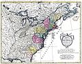 United States (1784)
 -
 Lower Saxony (1786)
 -
 Africa (1797)
 -
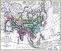 Asia (1805)


.png)

References
- ^ a b Bertuch, Friedrich Justin (1808). Allgemeine geographische Ephemeriden, Band 26. Weimar. pp. 255–262.
- ^ a b Seifert, Traudl, „Güssefeld, Franz Ludwig“, in: Neue Deutsche Biographie 7 (1966), S. 289 [Onlinefassung]; http://www.deutsche-biographie.de/pnd12196695X.html
External links
 Media related to Franz Ludwig Güssefeld at Wikimedia Commons
| International | |
|---|---|
| National | |
| Artists | |
| People | |
| Other | |
This cartography or mapping term article is a stub. You can help Wikipedia by expanding it. |
- Articles with hCards
- Commons category link from Wikidata
- Articles with ISNI identifiers
- Articles with VIAF identifiers
- Articles with WorldCat Entities identifiers
- Articles with BNE identifiers
- Articles with CANTICN identifiers
- Articles with GND identifiers
- Articles with J9U identifiers
- Articles with KBR identifiers
- Articles with LCCN identifiers
- Articles with Libris identifiers
- Articles with NKC identifiers
- Articles with NTA identifiers
- Articles with PLWABN identifiers
- Articles with PortugalA identifiers
- Articles with DSI identifiers
- Articles with DTBIO identifiers
- Articles with SUDOC identifiers
- 1744 births
- 1807 deaths
- People from Osterburg (Altmark)
- 18th-century German cartographers
- All stub articles
- Cartography stubs