File:EAST ELEVATION. - Ross Drive Bridge, Spanning Rock Creek at Ross Drive, South of Joyce Road, NW, Washington, District of Columbia, DC HAER DC,WASH,571-2.tif
Jump to navigation
Jump to search

Size of this JPG preview of this TIF file: 747 × 600 pixels. Other resolutions: 299 × 240 pixels | 598 × 480 pixels | 957 × 768 pixels | 1,276 × 1,024 pixels | 2,551 × 2,048 pixels | 4,874 × 3,913 pixels.
Original file (4,874 × 3,913 pixels, file size: 18.19 MB, MIME type: image/tiff)
Summary
| EAST ELEVATION. - Ross Drive Bridge, Spanning Rock Creek at Ross Drive, South of Joyce Road, NW, Washington, District of Columbia, DC | ||||
|---|---|---|---|---|
| Photographer |
Lowe, Jet Related names:
|
|||
| Title |
EAST ELEVATION. - Ross Drive Bridge, Spanning Rock Creek at Ross Drive, South of Joyce Road, NW, Washington, District of Columbia, DC |
|||
| Depicted place | District of Columbia; District of Columbia; Washington | |||
| Date | 1988 | |||
| Dimensions | 4 x 5 in. | |||
| Current location |
Library of Congress Prints and Photographs Division Washington, D.C. 20540 USA http://hdl.loc.gov/loc.pnp/pp.print |
|||
| Accession number |
HAER DC,WASH,571-2 |
|||
| Credit line |
|
|||
| Notes |
|
|||
| Source | https://www.loc.gov/pictures/item/dc0626.photos.030265p | |||
| Permission (Reusing this file) |
|
|||

| Object location | | View this and other nearby images on: OpenStreetMap |
|---|
File history
Click on a date/time to view the file as it appeared at that time.
| Date/Time | Thumbnail | Dimensions | User | Comment | |
|---|---|---|---|---|---|
| current | 10:27, 10 July 2014 | 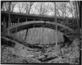 | 4,874 × 3,913 (18.19 MB) | commons>Fæ | GWToolset: Creating mediafile for Fæ. HABS 08 July 2014 (701:800) |
File usage
There are no pages that use this file.