File:Aerial views of the Houston, Texas, skyline in 2014 LCCN2014632225.tif
Original file (7,061 × 4,712 pixels, file size: 190.42 MB, MIME type: image/tiff)
This file is from a shared repository and may be used by other projects. The description on its file description page there is shown below.
Summary
DescriptionAerial views of the Houston, Texas, skyline in 2014 LCCN2014632225.tif |
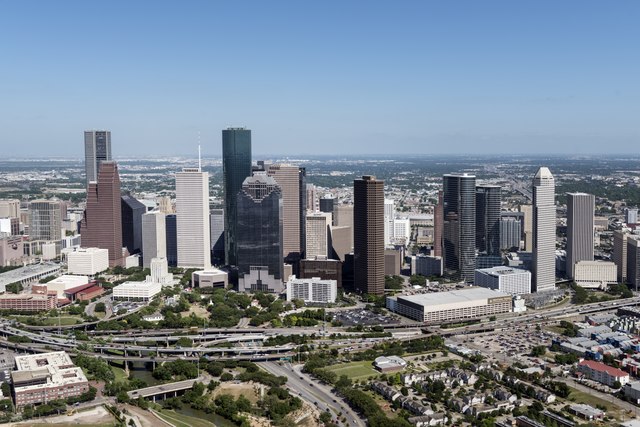
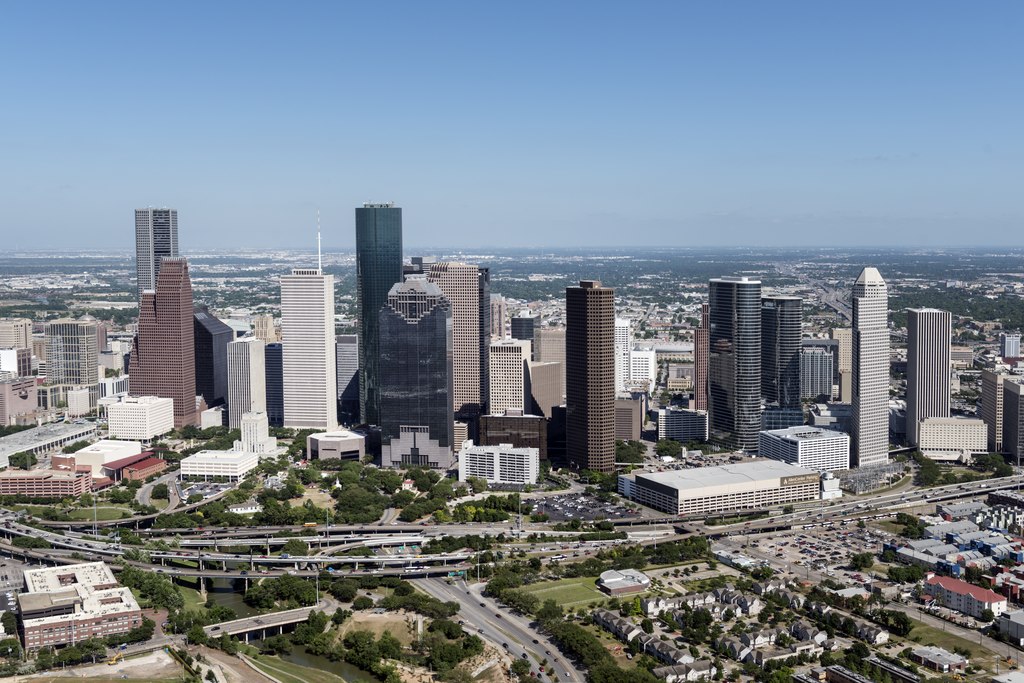
English: Title: Aerial views of the Houston, Texas, skyline in 2014
Physical description: 1 photograph : digital, tiff file, color. Notes: Title, date, and keywords based on information provided by the photographer.; Gift; The Lyda Hill Foundation; 2014; (DLC/PP-2014:054).; Forms part of: Lyda Hill Texas Collection of Photographs in Carol M. Highsmith's America Project in the Carol M. Highsmith Archive.; Credit line: The Lyda Hill Texas Collection of Photographs in Carol M. Highsmith's America Project, Library of Congress, Prints and Photographs Division. |
||||||||||||||||||||||||||
Date | Taken on 5 May 2014, 16:26 (according to Exif data) | ||||||||||||||||||||||||||
Source |
Library of Congress
|
||||||||||||||||||||||||||
Author |
creator QS:P170,Q5044454 |
||||||||||||||||||||||||||
Permission (Reusing this file) |
No known restrictions on publication.
|
Camera location | 29° 45′ 48.36″ N, 95° 22′ 59.85″ W | View this and other nearby images on: OpenStreetMap | 29.763432; -95.383293 |
---|
Licensing
Public domainPublic domainfalsefalse |
This work is from the Carol M. Highsmith Archive collection at the Library of Congress. According to the library, there are no known copyright restrictions on the use of this work. Carol M. Highsmith has stipulated that her photographs are in the public domain. Photographs of sculpture or other works of art may be restricted by the copyright of the artist. |
Items portrayed in this file
depicts
2014
29°45'48.355"N, 95°22'59.855"W
image/tiff
03a64c1ef20ac3851f0f7bc52529cf458c938bb9
199,665,056 byte
4,712 pixel
7,061 pixel
File history
Click on a date/time to view the file as it appeared at that time.
Date/Time | Thumbnail | Dimensions | User | Comment | |
---|---|---|---|---|---|
current | 07:31, 27 September 2016 | 7,061 × 4,712 (190.42 MB) | commons>Fæ | LOC 2014632225, Carol M. Highsmith collection. P755.21877 TIFF (190.4mb) |
File usage
There are no pages that use this file.
Metadata
This file contains additional information, probably added from the digital camera or scanner used to create or digitize it.
If the file has been modified from its original state, some details may not fully reflect the modified file.
Image title | Aerial views of the Houston, Texas, skyline in 2014. |
---|---|
Camera manufacturer | NIKON CORPORATION |
Camera model | NIKON D800 |
Author | Photographer: Carol M. Highsmith |
Exposure time | 1/640 sec (0.0015625) |
F Number | f/6.3 |
ISO speed rating | 100 |
Date and time of data generation | 16:26, 5 May 2014 |
Lens focal length | 38 mm |
Latitude | 29° 45′ 48.35″ N |
Longitude | 95° 22′ 59.86″ W |
Altitude | 272 meters above sea level |
Width | 7,061 px |
Height | 4,712 px |
Bits per component |
|
Compression scheme | Uncompressed |
Pixel composition | RGB |
Image data location | 33,572 |
Orientation | Normal |
Number of components | 3 |
Number of rows per strip | 4,712 |
Bytes per compressed strip | 199,628,592 |
Horizontal resolution | 300 dpi |
Vertical resolution | 300 dpi |
Data arrangement | chunky format |
Software used | Ver.1.02 |
File change date and time | 20:55, 8 May 2014 |
Exposure Program | Manual |
Exif version | 2.21 |
Date and time of digitizing | 16:26, 5 May 2014 |
APEX shutter speed | 9.321928 |
APEX aperture | 5.310704 |
APEX exposure bias | 0 |
Maximum land aperture | 3 APEX (f/2.83) |
Metering mode | Pattern |
Light source | Unknown |
Flash | Flash did not fire, compulsory flash suppression |
DateTimeOriginal subseconds | 2 |
Color space | Uncalibrated |
Focal plane X resolution | 2,048.4022216797 |
Focal plane Y resolution | 2,048.4022216797 |
Focal plane resolution unit | 3 |
Sensing method | One-chip color area sensor |
File source | Digital still camera |
Scene type | A directly photographed image |
Custom image processing | Normal process |
Exposure mode | Manual exposure |
White balance | Auto white balance |
Digital zoom ratio | 1 |
Focal length in 35 mm film | 38 mm |
Scene capture type | Standard |
Scene control | None |
Contrast | Normal |
Saturation | Normal |
Sharpness | Normal |
Subject distance range | Unknown |
GPS time (atomic clock) | 21:26 |
Satellites used for measurement | 13 |
Geodetic survey data used | WGS84 |
GPS date | 5 May 2014 |
GPS tag version | 2.3.0.0 |