File:AERIAL VIEW, LAUREL HILL CEMETERY (LEFT) AND MOUNT PEACE CEMETERY (RIGHT). LOCATED ACROSS RIDGE AVENUE FROM LAUREL HILL CEMETERY, MOUNT PEACE CEMETERY WAS FOUNDED BY THE ODD HABS PA,51-PHILA,100-105.tif

Original file (5,410 × 4,397 pixels, file size: 22.69 MB, MIME type: image/tiff)
Summary
| Photographer |
Boucher, Jack E. Related names:
|
|||
| Title |
AERIAL VIEW, LAUREL HILL CEMETERY (LEFT) AND MOUNT PEACE CEMETERY (RIGHT). LOCATED ACROSS RIDGE AVENUE FROM LAUREL HILL CEMETERY, MOUNT PEACE CEMETERY WAS FOUNDED BY THE ODD FELLOWS CEMETERY COMPANY IN 1865. - Laurel Hill Cemetery, 3822 Ridge Avenue, Philadelphia, Philadelphia County, PA |
|||
| Depicted place | Pennsylvania; Philadelphia County; Philadelphia | |||
| Date | 2003 | |||
| Dimensions | 4 x 5 in. | |||
| Current location |
Library of Congress Prints and Photographs Division Washington, D.C. 20540 USA http://hdl.loc.gov/loc.pnp/pp.print |
|||
| Accession number |
HABS PA,51-PHILA,100-105 |
|||
| Credit line |
|
|||
| Notes |
Yet the cemetery's significance extends well beyond an association with these individuals. In an era when cities suffered from crowding, disease, and scarcity of public space, Laurel Hill offered an "alternative environment." Amid clerical criticism and economic instability, the institution lured startling numbers of patrons and visitors. They came to experience artfully controlled nature; to see romantic monuments and to build them; to mix piety and patriotism, education and entertainment. Cemetery literature promised all of these things. Nonetheless, the institution ultimately placed property rights above public access. As Laurel Hill's visitation statistics fueled the Victorian crusade for urban parks, lot-holders built higher fences and managers wrote more restrictive rules. Today Laurel Hill stands as a landmark in the history of American architecture, landscape, and marketing. Spawned by a New Jersey Quaker's interest in horticulture, commemoration, and elite enterprise, it is an essay in Victorian taste and mores.
|
|||
| References |
|
|||
| Source | https://www.loc.gov/pictures/item/pa0961.photos.205736p | |||
| Permission (Reusing this file) |
|

| Object location | | View this and other nearby images on: OpenStreetMap |
|---|
| Annotations | This image is annotated: View the annotations at Commons |
File history
Click on a date/time to view the file as it appeared at that time.
| Date/Time | Thumbnail | Dimensions | User | Comment | |
|---|---|---|---|---|---|
| current | 07:27, 3 August 2014 | 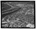 | 5,410 × 4,397 (22.69 MB) | commons>Fæ | GWToolset: Creating mediafile for Fæ. HABS 2014-08-01 2601-2900 missing |
File usage
There are no pages that use this file.