Cross Brook (New Jersey)
| Cross Brook | |
|---|---|
 Cross Brook crossing Jacques Lane | |
| Location | |
| Country | United States |
| Physical characteristics | |
| Source | |
| • coordinates | 40°27′7″N 74°33′33″W / 40.45194°N 74.55917°W |
| Mouth | |
• coordinates | 40°28′23″N 74°33′6″W / 40.47306°N 74.55167°W |
• elevation | 59 ft (18 m) |
| Basin features | |
| Progression | Six Mile Run, Millstone River, Raritan River, Atlantic Ocean |
| River system | Raritan River system |
Cross Brook is a tributary of Six Mile Run in Somerset and Middlesex Counties, New Jersey in the United States.[1]
Course
The source of Cross Brook is near Suydam Road in eastern Franklin Park, at 40°27′7″N 74°33′33″W / 40.45194°N 74.55917°W.[2] It flows through the Six Mile Run Reservoir Site and crosses Jacques Lane. After Jacques Lane it drains into the Six Mile Run at 40°28′23″N 74°33′6″W / 40.47306°N 74.55167°W.[2]
Animal life
Cross Brook is a slow-moving stream, although it is not marshy. Some species of fish may be expected to be found in it.
Terrain
The Cross Brook starts as a lake which drains into grasslands, forming a marshy area around its source. It is still muddy farther downstream. It tends to be a wide, slow, deep stream.
Accessibility
Cross Brook is a short stream, only crossing one road. There are a few trails in the woods that lead to it.
Sister tributaries
Gallery
-
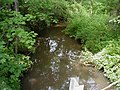 Cross Brook crossing Jacques Lane
 -
 Cross Brook flowing through grasslands near its source
 -
 Cross Brook crossing Jacques Lane


See also
References
- ^ Township of Franklin Topo Map. Somerset County. 2008.
- ^ a b "GNIS Detail – Cross Brook". United States Geological Survey. Retrieved 31 July 2010.[permanent dead link]
External links
This Middlesex County, New Jersey state location article is a stub. You can help Wikipedia by expanding it. |
This Somerset County, New Jersey state location article is a stub. You can help Wikipedia by expanding it. |
- All articles with dead external links
- Articles with dead external links from July 2020
- Articles with permanently dead external links
- Use dmy dates from July 2023
- Articles with short description
- Short description is different from Wikidata
- Coordinates on Wikidata
- Rivers of Middlesex County, New Jersey
- Tributaries of the Raritan River
- Rivers of New Jersey
- Rivers of Somerset County, New Jersey
- All stub articles
- Middlesex County, New Jersey geography stubs
- New Jersey geography stubs
- New Jersey river stubs