Cow Yard Brook (New Jersey)
Jump to navigation
Jump to search
| Cow Yard Brook | |
|---|---|
 Cow Yard Brook crossing Deans Lane | |
 Map of Cow Yard Brook | |
| Location | |
| Country | United States |
| Physical characteristics | |
| Source | |
| • coordinates | 40°24′43″N 74°32′8″W / 40.41194°N 74.53556°W |
| Mouth | |
• coordinates | 40°24′46″N 74°30′51″W / 40.41278°N 74.51417°W |
• elevation | 98 ft (30 m) |
| Basin features | |
| Progression | Oakeys Brook, Lawrence Brook, Raritan River, Atlantic Ocean |
The Cow Yard Brook is a small tributary of the Oakeys Brook, in central South Brunswick, New Jersey in the United States.
Course
The Cow Yard Brook starts at 40°24′43″N 74°32′8″W / 40.41194°N 74.53556°W[1] near the intersection of Beekman Road, Northumberland Way, and US Route 1. It crosses Deans Lane near its intersection with Black Horse Lane. It then crosses Black Horse Lane and drains into the Oakeys Brook at 40°24′46″N 74°30′51″W / 40.41278°N 74.51417°W,[1] near the intersection of Black Horse Lane and Henderson Road.
Accessibility
The Cow Yard Brook is very short, but it can be accessed by some of the roads it crosses and the Oakeys Brook.
Gallery
-
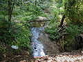 Cow Yard Brook at Deans Lane
 -
 Cow Yard Brook at Deans Lane

See also
References
- ^ a b "USGS GNIS - Cow Yard Brook". USGS. Retrieved 14 June 2010.[permanent dead link]
External links
This Middlesex County, New Jersey state location article is a stub. You can help Wikipedia by expanding it. |
Categories:
- All articles with dead external links
- Articles with dead external links from July 2020
- Articles with permanently dead external links
- Articles with short description
- Short description matches Wikidata
- Coordinates on Wikidata
- Rivers of Middlesex County, New Jersey
- Tributaries of the Raritan River
- Rivers of New Jersey
- All stub articles
- Middlesex County, New Jersey geography stubs
- New Jersey river stubs