Chadual
Jump to navigation
Jump to search
Chadual | |
|---|---|
village | |
 Chadual Location in Rajasthan, India  Chadual Chadual (India) | |
| Coordinates: 24°54′43″N 72°38′49″E / 24.91194°N 72.64694°E | |
| Country | |
| State | Rajasthan |
| District | Sirohi |
| Government | |
| • Body | Gram Panchayat |
| Languages | |
| • Official | Hindi Marwari |
| Time zone | UTC+5:30 (IST) |
| ISO 3166 code | RJ-IN |
| Vehicle registration | RJ-24 |
| Coastline | 0 kilometres (0 mi) |
Chadual is a village in Sirohi district in the Indian state of Rajasthan
Geography
It is located about 25 km west of Sirohi.[1]
Demographics
This village has many castes including Purohit, Rawal Brahmin, Rajput, Jain, Suthar, Mali, Prajapat, Bhatt Brahmin, Dewasi, Boda Prajapat, Meghwal and Bheel.
Governance
This village is represented by the Govt. Local Body Gram Panchayat tanwari.[how?]
Culture
This village has many Hindu temples and also one Jain temple.
Gallery
-
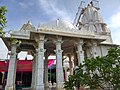 Shri Vaijnath Mahadev Temple in Chadual
 -
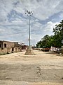 Chadual Bus Station


References
- ^ "Pin code Chadual". Pin code india. Retrieved 27 March 2017.
This article related to a location in Rajasthan is a stub. You can help Wikipedia by expanding it. |
Categories:
- Pages using gadget WikiMiniAtlas
- Use dmy dates from June 2018
- Use Indian English from June 2018
- All Wikipedia articles written in Indian English
- Articles with short description
- Short description matches Wikidata
- Coordinates on Wikidata
- Wikipedia articles needing clarification from March 2022
- Villages in Sirohi district
- All stub articles
- Rajasthan geography stubs