Carr Creek Lake
Jump to navigation
Jump to search
| Carr Creek Lake | |
|---|---|
 | |
 Carr Creek Lake  Carr Creek Lake | |
| Location | Knott County, Kentucky |
| Coordinates | 37°14′06″N 83°00′11″W / 37.235°N 83.003°W |
| Type | reservoir |
| Basin countries | United States |
| Surface area | 710 acres (3 km2) |
| Surface elevation | 1,020 ft (310 m)[1] |
Carr Creek Lake (formerly Carr Fork Lake), located east of Hazard, Kentucky, along Kentucky Route 15 in Knott County, is a 710 acres (3 km2) reservoir created by the U.S. Army Corps of Engineers in 1976.[2] Carr Creek Lake's earth and rock fill dam is 130 ft (40 m) tall and 720 ft (219 m) long, and the dam is located 8.8 mi (14 km) above the mouth of Carr Fork River, a tributary of the North Fork Kentucky River.[3]
The lake is the main attraction of Carr Creek State Park.[4]
-
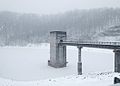 Control tower at Carr Creek Dam

References
- ^ U.S. Geological Survey Geographic Names Information System: Carr Creek Lake
- ^ Kleber, John E., ed. (1992). "Lakes". The Kentucky Encyclopedia. Associate editors: Thomas D. Clark, Lowell H. Harrison, and James C. Klotter. Lexington, Kentucky: The University Press of Kentucky. ISBN 0-8131-1772-0.
- ^ "Carr Creek Lake". U.S. Army Corps of Engineers. Retrieved 2007-02-17.
- ^ "Carr Creek State Park". Kentucky Department of Parks. 2005-10-10. Archived from the original on 2007-02-04. Retrieved 2007-02-17.
External links


This Knott County, Kentucky state location article is a stub. You can help Wikipedia by expanding it. |
Categories:
- Articles with short description
- Short description is different from Wikidata
- Pages using infobox body of water with auto short description
- Coordinates on Wikidata
- Articles using infobox body of water without alt
- Articles using infobox body of water without pushpin map alt
- Articles using infobox body of water without image bathymetry
- 1976 establishments in Kentucky
- Protected areas of Knott County, Kentucky
- Reservoirs in Kentucky
- Bodies of water of Knott County, Kentucky
- All stub articles
- Knott County, Kentucky geography stubs
- Kentucky geography stubs
- Southern United States protected area stubs