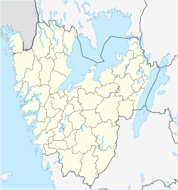
Brålanda
Jump to navigation
Jump to search
Brålanda | |
|---|---|
Town | |
 Brålanda church | |
| Coordinates: 58°34′N 12°22′E / 58.567°N 12.367°E | |
| Country | Sweden |
| Province | Dalsland |
| County | Västra Götaland County |
| Municipality | Vänersborg Municipality |
| Estimated founding | Early middle ages |
| First proof of settlement | 1382 |
| Current location | 1870 |
| Named for | The location of a bridge over the Frändeforsån (English: Frändefors River) |
| Seat | Vänersborgs Kommunhus |
| Government | |
| • Type | City Council |
| • Body | Vänersborg Municipality Council |
| Area | |
| • Water | 2.7 km2 (1.0 sq mi) |
| • Urban | 1.52 km2 (0.59 sq mi) |
| • Rural | 220.4 km2 (85.1 sq mi) |
| Elevation | 70 m (230 ft) |
| Population (1 January 2016)[1] | |
| • Urban | 1,385 |
| • Urban density | 908/km2 (2,350/sq mi) |
| • Rural | 2,267 |
| • Rural density | 10/km2 (30/sq mi) |
| Demonym | Brålandabo |
| Time zone | UTC+1 (CET) |
| • Summer (DST) | UTC+2 (CEST) |
Brålanda is a locality situated in Vänersborg Municipality, Västra Götaland County, Sweden with 1,385 inhabitants in 2010.[1]
It is situated 24 km north of the town Vänersborg, by the southern parts of lake Vänern. It is a conjoining town for the rural agricultural lands, and has a large storage silo for crops.
In the town there is one grocery shop, a swimming bath, a campground, and a small library.
References
- ^ a b c "Tätorternas landareal, folkmängd och invånare per km2 2005 och 2010" (in Swedish). Statistics Sweden. 14 December 2011. Archived from the original on 27 January 2012. Retrieved 10 January 2012.
Categories:
- CS1 Swedish-language sources (sv)
- Articles with short description
- Short description is different from Wikidata
- Coordinates on Wikidata
- Articles with VIAF identifiers
- Articles with J9U identifiers
- Articles with LCCN identifiers
- Populated places in Västra Götaland County
- Populated places in Vänersborg Municipality
- Dalsland
- All stub articles
- Västra Götaland County geography stubs

