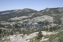
Beyers Lakes
Jump to navigation
Jump to search
| Beyers Lakes | |
|---|---|
 | |
| Location | Nevada County, California[1] |
| Coordinates | 39°23′06″N 120°33′18″W / 39.38500°N 120.55500°W[1] |
| Basin countries | United States |
| Surface elevation | 6,860 feet (2,090 m)[1] |
The Beyers Lakes are located in the Tahoe National Forest, in California.
They can be accessed via the Beyers Lakes Trail from Grouse Ridge Trail. Grouse Ridge trail can be accessed from the Eagle Lakes trailhead, off of Interstate 80, or from Grouse Ridge Campground.
They sit below the Black Buttes of Grouse Ridge, and are part of the Fordyce Creek watershed draining into Lake Spaulding.
See also
References
Categories:
- Articles with short description
- Short description is different from Wikidata
- Coordinates on Wikidata
- Articles using infobox body of water without alt
- Articles using infobox body of water without image bathymetry
- Lakes of the Sierra Nevada (United States)
- Lakes of Nevada County, California
- Tahoe National Forest
- Lakes of California
- Lakes of Northern California
- All stub articles
- Nevada County, California geography stubs

