Ballacolla
Jump to navigation
Jump to search
Ballacolla
Baile Cholla | |
|---|---|
Village | |
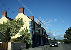
 Pub in Ballycolla | |
| Coordinates: 52°52′57″N 7°26′48″W / 52.8825°N 7.4468°W | |
| Country | Ireland |
| Province | Leinster |
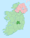
| County | County Laois |
| Population | 136 |
| Time zone | UTC+0 (WET) |
| • Summer (DST) | UTC-1 (IST (WEST)) |
Ballacolla, officially Ballycolla (Irish: Baile Cholla),[2] is a village in County Laois, Ireland. It sits at the crossroads of the R433 and R434 regional roads, 8 km (5.0 mi) southwest of Abbeyleix and 4 km northeast of junction 3 of the M8 motorway. ‘In Irish it is called Bolliacholla, i.e., Baile a’ Chalaidh, the townland of the ... long, coarse, sedgy grass’ de réir an Chorragánaigh; deir sé ‘Dr. Joyce’s explanation … town of a man named Colla, is incorrect’.[2]
As of the 2016 census, Ballacolla had a population of 136 people.[1]
References
- ^ a b "Sapmap Area - Settlements - Ballycolla". Census 2016. CSO. April 2016. Retrieved 24 January 2020.
- ^ a b "Baile Cholla / Ballycolla". logainm.ie. Placenames Database of Ireland. Retrieved 24 January 2020.

