Badajoz bastioned enclosure
This article may require copy editing for grammar, style, cohesion, tone, or spelling. (June 2023) |
| Badajoz bastioned enclosure | |
|---|---|
| Perimeter of old Badajoz in Spain | |
 "Plan of the siege that the rebel put on the city of Badajoz" (Planta del sitio que el revelde puso a la ciudad de Badajoz, sic) by Kungl Krigsarkivet in 1658. | |
| Coordinates | 38°52′55″N 6°58′08″W / 38.881914°N 6.968992°W |
| Type | Fortified and bastioned enclosure |
| Area | 6541 m of preserved wall (including the citadel-castle) |
| Site information | |
| Owner | Badajoz City Council |
| Condition | Restored; in very good condition |
| Site history | |
| Built | 17th to 18th century (prolonging an earlier defensive system from the 9th to the 16th century) |
| Built by | System of Sébastien Le Prestre, Marquis de Vauban or simply Vauban. |
| Materials | According to the different rehabilitation, masonry, dimension stone, brick and concrete |
| Bien de Interés Cultural as Conjunto histórico | |
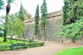
The bastioned system of the Spanish city of Badajoz consists of a military fortification formed by a set of defensive walls, city gates, bridges, forts, towers, bastions, hornworks, moats, tunnels and ravelins, among other defensive elements, built between the 17th and 18th centuries, following the defensive construction theories popularized by the French military engineer Sébastien Le Prestre, better known as the Marquis de Vauban, as an extension of a previous defensive enclosure that protected this border town.[1]
Ever since Ibn Marwan founded Badajoz (over an earlier Visigothic settlement, since settlements in Badajoz date back to prehistoric times), this city has always had a stronghold character that has been maintained until the 20th century. This is due to the privileged strategic location at a crossroads of two communication routes: one is the one from Castile to Andalusia, and the other from the plateau to Lisbon. In addition to being a border city with Portugal, this situation has been, on some occasions, a source of advantages for the development of Badajoz and on others, many more, a place of confrontation for various armies over the last few centuries. For these reasons, the city was protected by several defensive enclosures.[2]
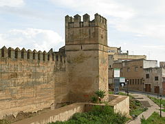
The first fortifications were carried out by Ibn Marwan, who ordered the erection of mortar walls. This was followed by the restoration carried out by Abd Allah Ibn Muhammad Ibn Abd al-Rahman, grandson of the founder of Badajoz, in 913. Later, in 1030, it was rebuilt by Abdallah ibn Al-Aftas, the first Aftasid king of the Taifa of Badajoz. Later, in 1169, the Alcazaba was built, very similar to the present one where some parts come from the first period of the Almohad domination. The last Muslim restoration was ordered by Abu Yahya ibn Abi Sinan, when he was governor of the city at the beginning of the 13th century.[3]
After the confrontations that took place between Castile and Portugal during the 14th century, the relations between both were normalized in an atmosphere of peace that lasted almost two and a half centuries. But in 1640, when Portugal became independent from the Hispanic Monarchy, Badajoz became a border city and because of its geostrategic position, the Castilian authorities realized the need to improve its current defenses in a very important way. It was then when the authorities of the Crown and Badajoz made the decision to carry them out. Among the various possibilities offered by the military engineers, it was decided to undertake the works following the system devised by Vauban. However, these works were not carried out in an orderly fashion, but rather it was improvisation, in the midst of a precarious economic situation, that prevailed, so that the reforms and improvements were successively made to the existing defenses.[4]
Background


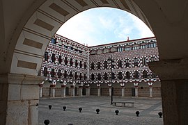
The city of Badajoz, specifically the oldest area, located in the highest part of the promontory called Cerro de la Muela, was defended by the enclosure built in the Islamic period, whose fortress is known as the Alcazaba. The city of Badajoz in Islamic times was surrounded by a defensive wall that protected the al-qasbah –ksar–, the citadel, an administrative area and residence of the rulers of the Kingdom of Badajoz (one of the largest taifas of the Iberian Peninsula), where the Alcázar, the mosque and one of the largest libraries of the time were located, whose defensive wall had successive extensions. The buildings of its interior are a proof of the different functions that the enclosure had in the different epochs: Islamic citadel, with different extensions until it reached an extension similar to the so-called "Cerca Vieja", −9th–13th centuries–, Christian late medieval castle, highlighting the first Badajoz Cathedral built on the palatial mosque, as well as different "fortified houses" to ensure its defense −13th and 16th centuries–, and as part of the citadel and fortification of modern construction −17th and 19th centuries–, highlighting in them different religious buildings, as well as the different secret passage and cisterns reused at different times.[5]
The city continued to grow outside the walls, especially to the west and south because of the flatter areas, encircled by a medieval wall of rammed earth of probable Almohad origin, with later extensions, which was followed by a late medieval pentagonal fence, contemporary to the Catholic Monarchs, at the end of the 15th century, which connects with the Palmas Gate at the height of the Palmas Bridge and the Pajaritos Gate, both from the 16th century, inside which were inserted the neighborhoods that form the historic district and whose defenses were insufficient in the face of the progressive development of artillery during the next century.[6][7] From 1642, in the context of the war with Portugal, is when a series of isolated and improvised defensive constructions began, as was the fort of San Cristobal, on the right bank of the Guadiana River, north of the city, on an important promontory called Orinaza Hill. This construction was considered the first of its kind in terms of defensive fortifications. In addition, this fort protected the head of the bridge, on the same bank of the river, which was an extremely strategic element since the bridge was the natural entrance to Badajoz. To protect the bridge, a series of defensive works were carried out, such as the demolition of several arches and their replacement by a drawbridge with three spans and the construction of parapets where the garrison of this outpost could be defended.[8]
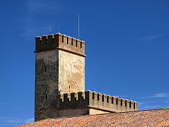
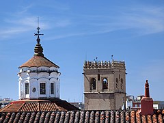
Shortly after, the Pardaleras fort was built at the opposite end of the city, that is, to the south of the city. Other defensive elements such as moats, walls, etc. were also added without following a certain order and were therefore not very effective. Nor were adequate materials used to cope with modern artillery which led to significant losses of land, buildings, etc. At the end of the 17th century, between 1690 and 1700, work began on the bastioned fortification. This new defensive wall started from the medieval wall, continued along the left bank of the Guadiana River to the bastions of San Vicente and Palmas Gate, turned west and then south through the bastions of San José, Santiago, Santa María and Trinidad Gate to finally connect with the defensive wall that protected the Alcazaba. Through the existing military cartography it is known that the watchtowers, from the Islamic period, were in use until the War of Independence, completing the defensive system (of the numerous watchtowers that Badajoz had in the past, fundamentally from the 12th century, only vestiges of five of them are conserved, standing out the Espantaperros Tower and the Tower of Los Rostros).[1]
- Gallery
-
 Abarlongada Tower from the chemin de ronde of the city defensive wall
 -
 Hanged Men Tower
 -
-
 Albarrana Tower
 -

-
 Front view of the Espantaperros Tower
 -
 Interior of the Alcazaba
 -
 Exterior of the Alcazaba
 -
 Interior door of the Alcazaba
 -

-
 Defensive walls and chemin de ronde of the Alcazaba of Badajoz
 -
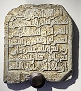 Sapur tombstone
 -
 Capital Gate
 -
 Capital Gate (back)
 -
 Curved gate
 -
 Views of the Alcazaba and the town halls from Plaza Alta
 -
 Carriage Gate or Yelbes Gate
 -
-
 Alcazaba Access
 -
 Lintel door
 -
 Alcazaba of Badajoz wall
 -
 Palace of the 16th century (Provincial Archaeological Museum)
 -
-
 Remnants of the Mosque-Cathedral (next to the old Military Hospital)
 -
 Alcazaba parapet
 -
 View from inside the Alcazaba


.jpg)

.JPG)


_-_panoramio.jpg)

_-_panoramio.jpg)
_-_panoramio.jpg)
History

Portugal and Castile maintained a series of confrontations in the 14th century. In the year 1580, Philip II moved the Court and the bulk of his army to Badajoz (being for eleven months his residence), annexing Portugal to the whole of the Hispanic Monarchy. The tensions for the city of Badajoz arose later, from 1640, given the proximity of the city to the border, as a consequence of the uprising of the Portuguese against the Crown of Castile.[9]
The bastioned enclosure began to be built in the 17th century, over a previous defensive system, when it was necessary to defend the square of Badajoz, seat of the General Captaincy of the Royal Army of Extremadura, due to the hostilities that led Spain and Portugal to the Portuguese Restoration War through which Portugal wanted to achieve its independence from Spain. Since then, Badajoz was consolidated as the capital of the Province of Extremadura and the most important border town among all those located near the border, which is why it was a place of great strategic interest for Spanish and Portuguese. The war lasted from 1640 to 1668, year in which by the Treaty of Lisbon, Spain recognized the complete independence of Portugal.[10]
Given its frontier character, the Badajoz Cathedral −13th–18th centuries– resembles a fortress: it has strong walls, battlements and a powerful tower where the bell tower is located. It was declared a Historic-Artistic Monument in 1931, as an Asset of Cultural Interest, being unique in its kind and time. The history of the Diocese and Bishopric of Badajoz dates back to the 10th century, currently holds the rank of Metropolitan Cathedral. Inside it houses an Islamic pottery of the 10th century and the Metropolitan Museum of the Cathedral. Nearby is the historical archive.[10]
The geographical features of the terrain on which the city of Badajoz sits conditioned since its foundation the consideration of a point of warlike and strategic interest and was a key point of the Spanish defensive system in the area since Portugal had its powerful defensive system of Elvas. For this reason Badajoz was the great stronghold of La Raya with Portugal. On the other hand, its geographical location in the Iberian Peninsula also made it a desirable place, since it is almost at the same latitude as Lisbon and almost equidistant from Madrid and Lisbon, although somewhat further away from Madrid and not too far from Oporto.[11][12]

- Gallery
-
 Exterior of the Cathedral-Fortress of Badajoz
 -
 Cathedral Door
 -
 Window detail
 -
 Door of the cathedral crypt
 -
 Top of the dome of the Church of the Conception, next to the tower of the Cathedral
_-_panoramio.jpg)


The onset of defenses


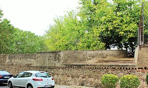
The bastioned enclosure was built on the foundations of the old medieval walled enclosure (9th to 15th centuries), which still existed until the 17th century; some sections were preserved, such as those next to the bastion of La Trinidad and the bastion of Santiago. The old medieval fence or "old fence" of the city (which prolonged the current citadel) had become outdated against the use of the artillery of the Portuguese army, mainly, since they had spent almost two and a half centuries of abandonment so it had aged to make it obsolete. In such a way it was so that the Count of Santiesteban wrote to the secretary Pedro Coloma about the defensive constructions in Badajoz, in which he commented that in Extremadura at that time −1643– there was no secure place in terms of defenses, provisions, artillery and other weapons. Only Badajoz seemed to have the minimum defensive conditions but the existing walled enclosure was totally ineffective. Only the upper part occupied by the alcazaba could have certain appropriate conditions and, therefore, the works of the new defensive walls should begin in that area.[13][14]
On the other hand, the Marquis of Torralbo wrote to the king in the following terms:
The inhabited enclosure of the Alcazaba encircled by the Almohad wall was with the fallen parapets and destroyed the faussebraye, as well as the doors, without closing or rake.
And he concluded by saying that it was within the reach of artillery, for which the rammed earth walls were absolutely ineffective:
... for it is within musket range from the fort of San Cristobal.[15][14]

Gradually this defensive wall was replaced by a new one that started from the Muslim citadel, followed the course of the Guadiana River along its left bank and made a turn to the west and south where the bastions of San Vicente and Palma Gate were built. The construction continued to the west, south and east, areas where the bastions of San José, Santiago, San Roque, Santa María and Trinidad were built, successively, until linking up again to the northeast with the old alcazaba by means of the bastion of San Pedro.[10]
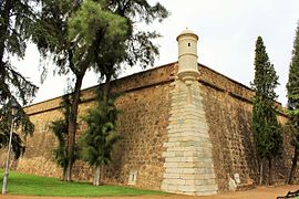
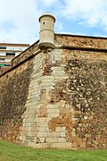
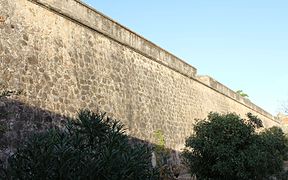
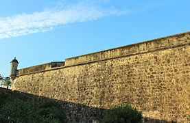
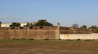
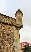
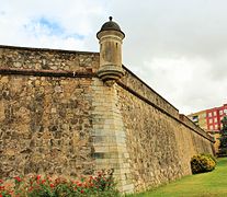
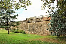
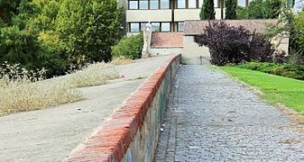
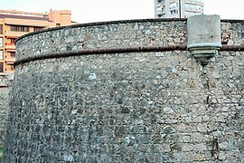
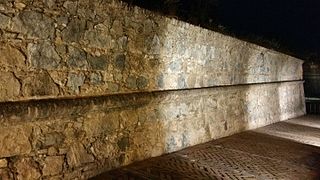
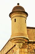
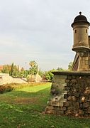
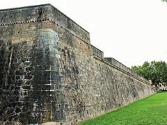
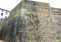
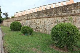
All the defensive elements that were built were adapted to the new trends in military engineering: lower and wider walls, to resist cannon fire and the introduction of bastions of large surface area, curtain wall flanks of the defensive wall that were buttressed instead of vertical to bounce the cannonballs upwards, half bastions that guarded the access gates, bartizan at the vertices of conjunction of two curtain wall of the defensive walls, moats in front of the defensive walls, lunettes and ravelins, etc. to hinder the action of the enemy. In spite of the serious and strong defensive structure, the defensive walls were decorated with a semicircular stone wall whose curved part was offered to the outside.[11]
The defensive system adopted was the one designed in his day by the French military engineer Sebastian Le Prestre, better known as Marquis de Vauban or simply Vauban.[16]
Elements

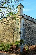
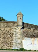
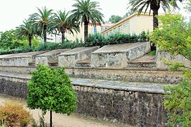
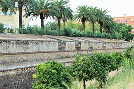
The bastioned enclosure is composed of several defensive buildings such as the curtain wall of the defensive walls, the gates, designed to allow and control the entry and exit of the inhabitants, the bastions consisting of pentagonal constructions, which joins two consecutive lines of defensive wall on the inner side of the pentagon, the forts located on the outside of the defensive walls and that were the first line of defense of the population and the ravelins that are triangular fortifications located in front of the body of the main fortification –generally on the other side of a moat– whose objective is to divide an attacking force and to protect the curtain wall of the defensive walls by means of crossfire. There are also other defensive elements such as moats, foothills, drawbridges, escarpments, etc. and some smaller buildings attached to or free of the enclosure.[10]
Bastions

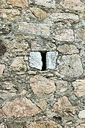
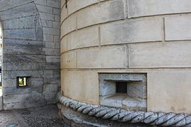
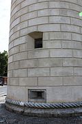
A bastion or bulwark is a fortified redoubt that projects outward from the main body of a fortress, generally located at the corners of the curtain walls, as a strong point of defense against the enemy. It may have openings in its walls such as arrowslits, embrasures, etc. In bastioned fortresses they usually have a polygonal plan and low height to offer the smallest possible impact surface to the cannon projectiles and slightly inclined so that they do not impact frontally and bounce upwards. They usually have a moat in front and also foothills to increase their defensive power.[17]
There are different names to define each of the bastions according to the type and form of construction, such as "pincer bastion", "cut bastion", "orillon bastion", "prominent bastion", "double bastion", "irregular bastion", "full bastion", "regular bastion", "simple bastion", "empty bastion", etc.[18]
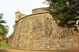
Semi-bastion of San Antonio


It is number 1 on the Plan of bastions. This semi-bastion joined the primitive alcazaba by its eastern zone with the rest of the bastioned enclosure. For its construction the old Alpendiz Gate was closed. To fill it with earth and stones on the inside so that it could withstand the impacts of the modern artillery, the materials of the Torre Vieja (Old Tower) were used, so it was left bareheaded. It was a tower that was part of a fortified enclosure with which it is communicated, although generally exempt from the defensive wall. What was left of the Old Tower was hidden due to this enclosure and to the fact that it remained inside the bastion. To replace the Alpendiz Gate a small door was opened as a gateway.[19]
It was built in the neighborhood of San Salvador and nowadays it is next to a modern park. When the Torre Vieja (Old Tower) was removed, it was buried, but in excavations carried out at the end of the 20th century, a large part of it was discovered.
A tour of the exterior from the southern part of this bastion to the junction with the defensive wall of the Alcazaba facing east.
- Gallery
-
 Southern curtain wall with a mark of artillery bullet impact
 -
 Southern curtain wall with marks of artillery bullet impacts
 -
 Southern curtain wall very elevated on rock
 -
 Old defensive walls outside the bastion on the east side
 -
 Outer wall, of lesser size
 -
 Curtain wall of the bastion, old defensive walls and, in the middle, the moat
 -
 Eastern curtain wall and, in the corner, another one to the north. In the background another to the east
 -
 Moat between the bastion and the old defensive wall
 -
 Northern curtain wall elevated on rock. In the background the Espantaperros Tower
 -
 Three curtain wall of the bastion next to the junction with those of La Alcazaba
 -
 High area of the bastion with embrasures in the upper part
 -
 Coat of arms over the Merida Gate
 -
 Open gate when the Alpendiz Gate was closed
 -
 Entronque of the bastion with the defensive wall of La Alcazaba
 -
 Diagram of the Old Tower hidden by the bastion with upper embrasures
 -
 View of the interior of the bastion from its highest point
 -
 View towards Merida from the upper part of the bastion and embrasures
 -
 North and east curtain wall of the junction with La Alcazaba


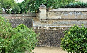
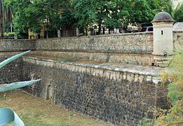
Bastion of San Pedro


It has the number 2 in the Plan of bastions. It is located next to the "Semi-bastion of San Antonio" and before the one of Trinidad, in the eastern zone of the bastioned enclosure, in front of the Rivillas river. Between these two bastions is the Merida Gate. Its construction dates from the last decades of the 17th century, the same period as that of the bastion of Trinidad, making both the oldest bastions in the enclosure.[16] It had a series of bartizan of which only their bases remain, as well as embrasures at the top of the defensive wall, but at present there are no remains of them. In 1772 the right flank of the bastion was provided with a series of arrowslits connected by a gallery for the circulation of the riflemen. The interior zone is very deteriorated.[20]
This bastion was of great importance during the War of the Spanish Succession since Badajoz suffered several sieges at that time; the most important was in 1705 when the supporters of Archduke Charles of Austria laid siege to Badajoz, which was defended by French and Spanish troops who remained loyal to Philip of Anjou. To take the city, the attackers established their artillery batteries on the other side of the Rivillas stream, at the height of "La Picuriña" and next to the hermitage of San Roque.[21]

Their intentions were to attack the city by the weakest defensive side and open a breach in the defensive wall that allowed them to penetrate it, for which they focused the shots on the bastion of San Pedro and managed to open a breach but the arrival of French reinforcements dissuaded them from entering the assault. The experience gained from this conflict led the commanders of the troops of Badajoz to reinforce the defenses of this area and built a ravelin, which they called the ravelin of San Roque, and a fort outside the defensive walls that was called the fort of the Prince and later renamed the fort of the Picuriña.[21] The redcoats of the future Duke of Wellington, commanded by the General of the 3rd Division Thomas Picton, entered this area in 1812 after the third assault for the liberation of Badajoz, which resulted in a large number of casualties. As a reminder of this combat, the soldiers marked the date "1812" on one of the curtain wall of this bastion by tearing out the corresponding stones so that the date could be seen. Still visible in its corners are the impacts of the cannonballs of the War of Independence.[22]
- Gallery
-
 Beginning of the bastion in its northeast zone
 -
 Several walls on the east flank
 -
 Several walls on the east flank
 -
 Angled walls
 -
 Rehabilitated interior area of the bastion with door and upper gate
 -
 Large south-facing wall
 -
 Old sketch of the bastion with the Rivillas stream in front of it


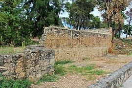
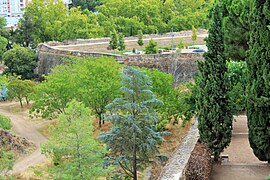
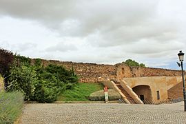
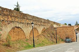
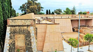
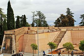
Bastion of Trinidad


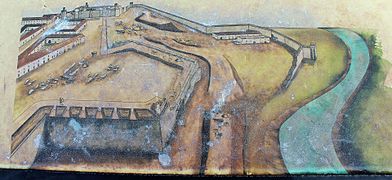
It has the number 3 in the Plan of bastions. It is located in the northeast corner of the walled enclosure, where the medieval tower called Torre del Canto was located, between the bastion of Santa María and the bastion of San Pedro. To the left of this section, in the old map entitled Plan of the Square and Castle of Badajoz, capital of Extremadura and border with Portugal, drawn by Jean Gabriel de Mercier de Chermont in 1775, it is observed that in front of the bastion and protecting its walls there is a counterguard marked with no. 22. It is also observed that the Convent of the Trinity, marked with no. 46, occupies almost the entire interior of the bastion.[23]
It is the oldest bastion of the bastioned enclosure of Badajoz along with that of San Antonio, since both were built in 1680. This name is due to the fact that in its interior, before being destroyed, there was the convent of the Trinitarians from the 13th century, which largely conditioned the layout of the bastion. Some of the engineers participating in the project, such as Luis de Venegas, wanted to set back the defensive wall in such a way that the convent would be outside the walled enclosure, while others, including Francisco Domingo, planned a layout with the convent inside the bastion, as was done, a solution that was highly criticized by the military engineers in charge of the defense of the square since, by surrounding it, this area was at a very low level and easily attacked from the heights of "La Picuriña". Of this convent there are only some remains since its stones were used to rebuild the bastion; it had several bartizan for surveillance and observation but there are no remains of any of them. The embrasure openings that it had on all its sides and arrowslits for rifles at half height of the curtain wall are visible. Along the entire length where there are loopholes, there was an interior corridor for communication between the riflemen and between them and the interior of the enclosure.[24]
The plan drawn by Luis de Venegas in 1677 shows the different layouts proposed for the area of the defensive wall facing the Rivillas stream. The medieval wall is marked in red; a first layout that left the convent of La Trinidad outside the defensive walls is marked in green and the layout that housed the convent inside the enclosure is in black. This layout is very close to the one that was definitively made. The covered way to the outside is marked in yellow.[25]
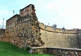
This bastion was destroyed in the sieges that the French forces exercised on the city in 1811 and 1812 on the occasion of the War of Independence and was rebuilt in the last third of the 20th century.[26]
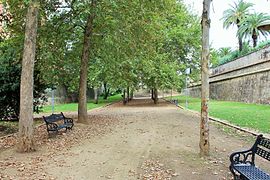
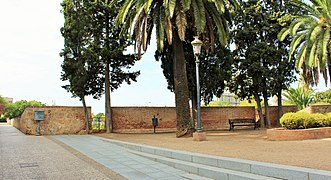
In the public park that was built inside, there are several statues by Juan de Avalos: one is a sculptural group representing the "Fallen Hero"; four others, in bronze and by the same author, represent the four evangelists as they are in the Valley of the Fallen.[27]
- Gallery
-
 Interior of the bastion with embrasures on the defensive wall
 -
 Communication opening between the chemin de ronde and the interior of the bastion
 -
 Window of communication from the interior with the parapet
 -
 Large curtain wall with embrasures and arrowslits
 -
 Ramp up and access to the parapet
 -
 Interior accesses to the chemin de ronde and postern
 -
 East flank. Beginning of the bastion seen from the inside
 -
 View where the opening for vehicular traffic was made
 -
 Beginning of the bastion; eastern curtain wall
 -
 Spillway or sewer at the bottom of a curtain wall
 -
 Detail of spillway or sewer in the lower part of a curtain wall
 -
 Embrasures and cannons in position over the Trinidad Gate
 -
 Inner area of the east of the bastion
 -
 Inscription on the exterior of the bastion's curtain wall
 -
 Access ramp to the chemin de ronde from the exit door
 -
 East flank. Beginning of the bastion seen from the bastion of San Pedro
 -
 Wall and beginning of the bastion. Eastern curtain wall


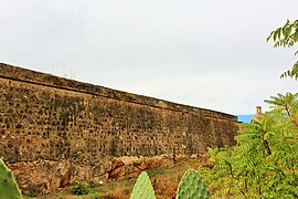
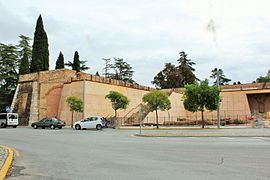
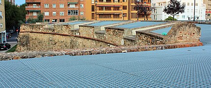
Bastion of Santa Maria


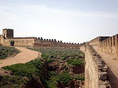
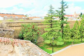
It has the number 4 in the Plan of bastions. It is flanked by the bastions of La Trinidad and San Roque. It was also called "La Laguna" because the outer moat could be flooded by the waters coming from some small dams built in the Rivillas stream, which increased its defensive capacity. In this way, a good part of the walled city became an island of difficult access.[28]
It was built in the 17th century but was almost totally destroyed after the siege and assault on Badajoz by French troops in the War of Independence in 1812, so that Lord Wellington's forces belonging to the 3rd Division and the Light Division, took the city but left this bastion in ruins. Between the moat of this bastion and that of the Trinity there are a few remains of a cemetery where the British killed in combat were buried.[28]
It was rebuilt in the 18th century and as a reminder of the date of its destruction, the date of 1812 was also engraved on this bastion and also on that of the Trinity, by means of holes left by cannonballs that made up that number. The bastion has the embrasures of fourteen cannons: four in the front and five on each side. Of the bartizan that were on each corner, which formed two curtain wall, only two remain. When the bastion was rebuilt, it was provided with rifle galleries.[29]
The bastion is currently surrounded by buildings, especially in the southeastern area, and a large amount of undergrowth, which means that it is practically hidden from public view.[29]
- Gallery
-
 Corner curtain wall, bartizan and spillways in low area
 -
 Degraded corner bartizan
 -
 Curtain wall with embrasures and date 1812 engraved with the shots fired with cannonballs by Wellington's troops to commemorate the assault on the two bastions.
 -
 Corner curtain walls with good masonry, bartizan and spillways in the lower zone.
 -
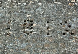 Detail of the date 1812 engraved with shots fired by British artillerymen to commemorate the assault on the two bastions.
 -
 Exterior wall. Bullring in the background
 -
 South and west curtain walls at the corner with bartizan
 -
 Two curved corner curtain walls
 -
 Strong curtain wall to the east with bartizan in the background
 -
 Corner of ashlars and bartizan
 -
 Sharp south-east corner, of ashlars, and bartizan at the ends.
 -
 Detail of bartizan in south-west corner
 -
 Strong south curtain wall with bartizan in the background
 -
 Bartizan between south and west curtain walls
 -
 Monument to the Fallen in the War against France
 -
 Large south curtain wall with bartizan and embrasures
 -
 Perspective of large south and west curtain walls
 -
 Large west curtain wall with bartizan and embrasures
 -
 Weaker western and southern curtain walls


Bastion of San Roque


It has the number 5 in the Plan of bastions. It is located between the bastion of Santa María and the now disappeared bastion of San Juan, in the southern part of the bastioned enclosure and is bounded by Estadiu street and the Ronda del Pilar.[30] Its original construction dates back to the 17th century. During the 18th century it was reinforced with a series of defensive elements of rifles and cannons. Sixteen embrasure were built: four of them were in the front and six on each flank or curtain wall of lateral defensive wall. It was also endowed on the left flank with galleries for riflemen and arrowslits so that they could develop their defensive function.[10]
In 1818 a bullring was built in the inner part of the bastion, but when a more modern one was built in the 20th century it fell into disuse and was demolished. This last bullring was destroyed in 2006 and the Conference Center of Badajoz was built in its place.[30]
The image gallery shows the bastion starting from the outside, next to Pilar Gate, continuing towards the east and then showing it in the opposite direction, already on the inside, until arriving again at Pilar Gate.
- Gallery
-
 Start-up of the bastion in Pilar Gate
 -
 Corner of south and west curtain walls
 -
 bartizan to the south
 -
 Southern and western curtain walls and bartizan at the junction
 -
 Auditorium protruding from a curtain wall
 -
 Detail of bartizan at the curtain walls junction
 -
 Southern curtain wall and bartizan in the background
 -
 bartizan at the junction of the eastern and southern curtain walls
 -
 East end with large openings for traffic
 -
 Western and southern curtain wall with front gracis
 -
 East end with large gap for traffic
 -
 Arrowslit detail
 -
 Detail of the interior of the bartizan
 -
 Gun port on a south curtain wall
 -
 Detail of the attack on the bastion of San Roque. Jacques Pennier, 1705
 -
 Detail of embrasure
 -
 Embrasure at the top
 -
 South flank and bartizan in the background
 -
 Junction of the bastion with Pilar Gate


Bastion of San Juan
The bastion of San Juan, which is number 5 on the Plan of Bastions, was located between the bastion of San Roque and the bastion of Santiago. It was demolished in its entirety to provide road access to the center of Badajoz through Europa Avenue. The Plan of bastions shows the plan of what was once the bastion of San Juan. Thus disappeared several centuries of history of a part of the bastioned enclosure of Badajoz.[30][31]
This bastion, very close to the Pilar Gate and demolished in the 1950s, was also known as the bastion of the Bomba because inside it there was, for many years, a Cavalry barracks called Cuartel de la Bomba.[32] The area left by the bastion was later urbanized and its main street was General Rodrigo Street in memory of the soldier who took part in the occupation of Badajoz during the Spanish Civil War. Later the name was changed to "Avenida de Europa".[33]
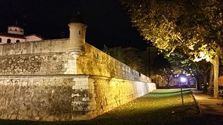
Bastion of Santiago


It has the number 6 in the Plan of bastions. It is located at the end of Menacho Street, between the bastion of San Juan to the east, which has completely disappeared, and the bastion of San José to the west, all of them in the southern part of Badajoz. The bastion, pentagonal in plan, was built in the 17th century and underwent many modifications in the 18th century. On its right flank an orillon was built, a semicircular element whose mission was to defend the curtain wall of the defensive wall between two consecutive bastions –or bastions that protruded with respect to the flank on which they were located–. They also had the purpose of protecting the postern. It had bartizan in the orillon and in all the vertexes, although only the one located in the orillon remains.[10] At present the bastion is isolated from the walled enclosure due to the demolition of the wall that joined it with the bastion of San José by the westernmost area and of the bastion of San Juan by the later disappearance of this one.[34]
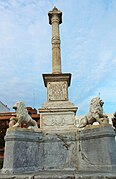
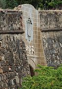
It is also called "bastion of Memory" because of the heroic deed of General Menacho, who died in 1811 while defending the city of Badajoz from the attacks of the French army.[35] After his death he was replaced by Brigadier Imaz who surrendered the square to the French troops. In 1852 a commemorative inscription was placed on this bastion, right in the place where he was killed. Part of the monument is preserved, as the four lions carved in marble, resting on their haunches, are missing. The project of the monument was of Julio Carande, captain of Engineers, and the realization was in charge of the marble workers Almendro and Zoido. It was inaugurated on 2 May 1893, with an inscription in memory of General Menacho, a Spanish soldier who took part in the Spanish War of Independence in the defense of Badajoz and died in combat in 1811. Marble from Alconera was used for the execution of the pedestal and the staircases and marble from Borba was brought for the rest. The tombstones with the corresponding inscriptions were carved in marble brought from Italy.[36]
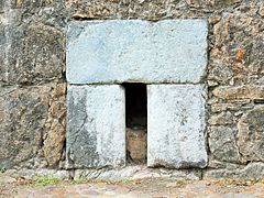
At the end of the 19th century, work was carried out to provide it with a postern, but it never fulfilled its specific mission, which was to be a small service gate open in the defensive wall for easy communication with the outside through the moat and a simple and secure system of closure in case of external attack. Its use was to serve as a storehouse.[37]
During the construction of a parking lot, some sections of older sections of curtain wall of the defensive wall were found, which are visible from a very specific point, difficult to access, on its northwest flank and also from inside the parking lot itself, since they were expressly left in sight. An Arab cemetery from the 10th and 11th centuries was also found.[38]
The gallery of images shows the bastion starting from the outside, from its beginning, behind the Government Delegation, continuing towards the west and then showing it in the opposite direction, already on the inside, until arriving again at the beginning, on its southern flank.
- Gallery
-
 Union of two curtain walls at the eastern end of the bastion
 -
 Night view of the strong south curtain wall with upper embrasures
 -
 South curtain wall at the junction with orillon and guard house
 -
 Orillon at western end with bartizan
 -
 Concave curtain wall at west end with upper embrasures
 -
 Continuation of the concave curtain wall with upper embrasures
 -
 Detail of a decommissioned bartizan in the west side of orillon
 -
 Orillon in the west zone, defensive walls, embrasures and bartizan
 -
 Orillon west with remains of bartizan
 -
 Junction of concave defensive wall with old defensive wall
 -
 Remains of defensive wall at the western end
 -
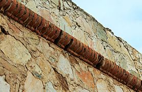 Detail of welt on the top of the curtain wall
 -
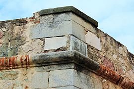 Detail of the joint at the crown of the south and west curtain wall
 -
 West end with old defensive wall recently uncovered
 -
 Embrasures on the concave defensive wall of the west flank
 -
 Monument to G. Menacho
 -
 Detail of the base of the monument to General Menacho.
 -
 Detail of the base of the monument to General Menacho.
 -
 Detail of the base of the monument to General Menacho
 -
 Museum of the Carnival of Badajoz in the postern
 -
 Public parking at the postern
 -
 Detail of a deconstructed bartizan
 -
 Location plan of the bastion on enclosure


.jpg)


Bastion of San José


It has the number 7 in the Plan of bastions. It is flanked by the bastion of Santiago on the south, and by the bastion of San Vicente in its southwest wing. It is not joined to the bastion of Santiago since the curtain wall that joined them was demolished to allow the passage of Columbus Avenue, which joins the center of Badajoz with its expansion area to the west. The curtain wall that joins it to the bastion of San Vicente is in perfect condition and has remained intact since its construction, which began in the last third of the 17th century. It was reformed and enlarged in the 18th century and was provided with a reinforcement a short distance from the crown of the curtain walls. It was endowed with eight embrasure, four pointing towards the bastion of Santiago, two towards the ravelin and another two towards of the curtain wall of the defensive wall that joins it with the bastion of San Vicente.[39]
Between 1772 and 1777 a good part of the bastions were reinforced to give them greater thickness and, therefore, greater resistance to artillery fire, among them the Bastion of San José. It was endowed with two "riflemen's galleries", also called "Galería Aspillerada" because of the openings or arrowslits used by the riflemen. It is the only bastion that conserves both galleries although the one located on the left flank is practically sunken. It is also preserved in good condition a piece of the covered road, which surrounds the entire bastion, whose defensive function was to discover the enemy long before he approached the defensive wall without the defenders who circulated along it could be seen by the enemy. For this reason it constituted the first defensive line. This bastion more than fulfilled its defensive function although it is true that it intervened in few sieges despite the many that the city had. It was the area least punished by enemy artillery.[36][40]
The route is done on the outside starting from the southern end of the bastion, which is the area closest to the bastion of Santiago, separated almost only by Avenida de Colón, ending at its southwestern end and then continuing through the interior of the bastion.
- Gallery
-
 Southern and western curtain walls with corner bartizan
 -
 Union of the strong southern and western curtain walls
 -
 Strong north-western curtain wall
 -
 Curtain wall crowning detail
 -
 Bartizan and moat
 -
 Detail of bartizan
 -
 bartizan, moat and ravelin in the background
 -
 South-western corner of the bastion
 -
 Strong north-eastern curtain wall
 -
 Detail of the grove under the embrasures
 -
 Interior of the bastion with embrasures


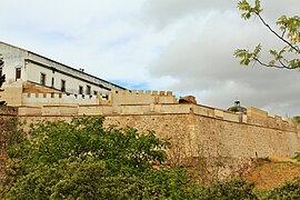
Bastion of San Vicente


It has the number 8 in the Plan of bastions. It has on its left flank, to the west, the bastion of San José and on the right, to the northwest, the semibastion of Palmas Gate. The bastion was built in the 17th century and its fire covered the northwest part of the bastion of San José. It maintains in perfect state an orillon in the left end. Together with that of the Bastion of Santiago, they are the only ones that conserve this defensive system. It has openings, by way of embrasures to lodge pieces of artillery of great caliber, on the orillon, on the poterna and in the flank that gives front to the Guadiana River. It has bartizan in the corners that form the curtain walls as well as on the "orillon". This bastion and the one of San José are the most attractive for the visitors since in both they conserve a great variety of defensive elements of the epoch.[41]
- Gallery
-
 Left flank. Union of the western and northern curtain walls
 -
 Detail of arrowslits for rifles
 -
 Access door to the moat from the postern
 -
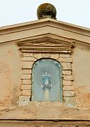
 Chapel dedicated to the Our Lady of Solitude, patron saint of the city, with an image of her inside. It was built moving in its entirety the facade of the old chapel located in the current square of the same name where today stands the building of La Giraldilla and was attached to the curtain wall of the defensive wall between the bastions of Saint Joseph and Saint Vincent
 -
 Inscription on tombstone, outside
 -
 Exit from the pothole to the moat and riflemen's gallery to the left
 -
 Orillon that protects the entrance to the postern, bartizan and embrasures
 -
 Orillon that protects the entrance to the postern, bartizan and embrasures
 -
 Details of bartizan, embrasures and curtain wall on north side
 -
 Detail of curtain wall between bartizan and upper embrasures
 -
 Northwestern curtain wall and park executed in the moat
 -
 Northwest curtain wall between two bartizan
 -
 Powerful north curtain wall
 -
 Descent to the postern from inside the bastion to the moat
 -
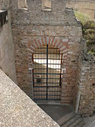
 Postern Gate


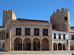
Semi-bastion of Palmas Gate


Also known as Baluarte de las Lágrimas (Bastion of Tears), it is number 9 on the Plan of Bastions. It is located on the left flank of Palmas Gate. The Palmas Gate had a series of defensive elements among which was this semi-bastion which is the only building that remains. The semi-bastion has two curtain walls forming an angle: one is oriented towards the Guadiana River and the other towards the west that connects at the end with the bastion of San Vicente. This wall has three embrasures in its crown facing west to protect with its fire the possible assault to the moat of the bastion of San Vicente.[42][43]
The route begins at its junction with the bastion of San Vicente, on the outside, up to the Palmas Gate and back inside, in the upper area of the bastion, in the opposite direction.
- Gallery
-
 Continuation curtain wall of the Bastion of San Vicente
 -
 Continuation curtain wall of the Bastion of San Vicente with upper embrasures
 -
 Three "Z" curtain wall with intermediate bartizan
 -
 One of the curtain walls of the "Z" with bartizan and exit from the postern to the moat
 -
 Strong northern curtain wall
 -
 End of north curtain wall with embrasures and descent to the moat
 -
 Descent from inside the defensive wall to the moat. Detail of the upper wall
 -
 Final gates of the semi-bastion
 -
 Inner area of the defensive wall near the Palmas Gate
 -
 Crimp corner between the outer curtain wall and the curved wall next to the gate
 -
 East end of the semi-bastion next to the Palmas Gate
 -
 Interior of the semi-balustrade with embrasures, near the Palmas Gate
 -
 Curtain wall to the west with embrasures defending the moat and Palmas Gate in the background
 -
 Western curtain wall with embrasures defending the moat and east descent
 -
 Curtain wall with embrasures and arrowslits for rifles


Gates

The gates of the bastioned enclosures were the openings made in their "curtain walls" for the entry and exit of people and carriages as well as for their control. Until the middle of the 20th century they were opened at dawn and closed at dusk. They also exercised a fiscal effect since it was where taxes, then called tariffs, were paid on certain goods entering the city. Although in the last years of operation of this type of tax collection they were collected at the Palmas Gate, on the side entrance road, years before it was done in the middle of the Palmas Bridge where there are two bartizan in the form of merlon towers.[44]
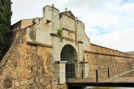
Merida Gate


It is the door that has the number 10 in the "Plan of gates". It is located in a place called "Campillo", south of the Alcazaba.[45]
At first this gate was in the primitive Almohad defensive wall of the 13th century and located a little further east, on a curtain wall of the Bastion of San Pedro and that gave entrance to the city by the old road from Talavera from Merida and hence its name, although it was necessary to ford the Rivillas stream to access it. As the construction of the Vauban type defensive system began in the 17th century, its location was modified and it was moved to the place where it is located, between the bastions of San Pedro and San Antonio. It was flanked by two large square towers, one on each side of the gate, and other types of defenses.[46]
Despite this move, the gate had to be rendered unusable because the works of the new defensive system required a quarry that was located on the outside of the gate, which caused a large, almost vertical slope that made it impossible to use, so it had to be walled up. At present, at the beginning of the 21st century, it is still impracticable and inaccessible from the outside.[47]
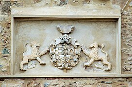
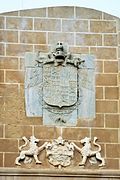
It has a coat of arms of Great Britain very close to it as a souvenir and tribute of the Cortes of Cadiz to Lord Wellington for his participation and help in the conquest of Badajoz from the French in 1812 and that of the Count of Montijo, then Captain General of Extremadura, since he was one of the great promoters of the construction of the bastioned enclosure. Over the door was built a chapel that was dedicated to the Virgin of Tentudía, now disappeared.[45] On the interior façade there was an area for the personnel guarding the gate and for the aforementioned chapel. The arch of the exterior facade is built by big dimension stone and carved stones in wedge form, of granite, that were of the old door. In the upper part of the arch of the facade there are some stone blocks on which are fixed the coats of arms of King Charles V, which is the one that was placed on the original door, and the Count of Montijo that replaced the coat of arms of Badajoz.[48]
- Gallery
-
 Interior side view
 -
 Exterior view from the first defensive barrier
 -
 View of Badajoz drawn by Pier Maria Baldi in 1668. The Merida Gate was then in its former position
 -
 Coat of arms of Charles V above the gate
 -
 Exterior view of the door with no possibility of access due to the great difference in level
 -
 View of the defensive wall and gate


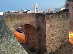
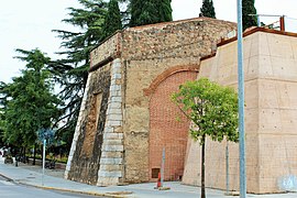
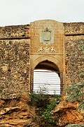
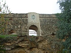
Gate of La Trinidad


It has the number 11 in the Plan of gates. It is located next to the bridge of San Roque, at the beginning of the round of the Pilar, in front of the Monument to the Fallen Hero, and gives access to the bastion of the Trinity". It was built in 1680, with granite ashlars, and is crowned on the outside with the coat of arms of Charles II as it was built during his reign. On the defensive wall above the gate there are several embrasures for large caliber artillery. This gate, like other pre-existing ones, was demolished to build the new defensive system and another similar one was built, which is the one that remains today. Contrary to what happens with other gates, which are placed in the middle of a curtain of the defensive walls between two consecutive bastions, it was opened in a flank of the bastion of the Trinity, which was considered one of the biggest mistakes in the design of the defenses.
In this place the width of the defensive wall is about twelve meters. The passage under the defensive wall is made under a very wide barrel vault. The interior facade is simple in appearance and is only decorated by a pair of spiral-shaped figures with the date of construction: 1680. It also has a small postern, that is to say, a hidden and semi-hidden secondary door, whose mission was the quick exit to the moat and drainage of rainwater. Between 1930 and 1940 a part of the bastion itself was demolished so that road traffic could pass through, to the detriment of a historical element of the city.
- Gallery
-
 Plaque with the legend "YEAR" (of its construction)
 -
 Plaque with the legend "1680" (year of construction)
 -
 Coat of arms of Charles II on the exterior facade
 -
 Stonemasons' marks on ashlars
 -
 Stonemasons' marks on ashlars
 -
 Exterior Facade
 -
 Gate of La Trinidad and southwest-facing curtain wall
 -
 Interior Facade


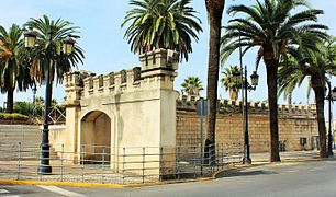
Pilar Gate


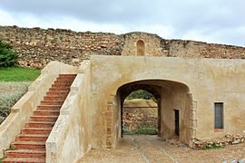
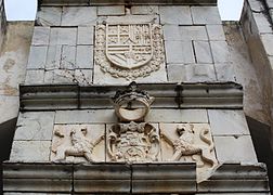
It is number 12 on the Plan of gates. It is located in the southwestern part of the defensive system, between the bastion of San Roque and San Juan and was built in 1692. It was one of the most exposed to enemy fire and therefore was protected with a glacis and in front of it was the "Fort of Pardaleras" with which it was communicated by a "covered road" from enemy fire where they could safely make the relief of the troops defending the fort, its ammunition and other services such as the provisioning of food, water, etc.[49] Originally it had a drawbridge to allow crossing the moat that surrounded the city. The openings that housed the system of levers on both sides of the gate that raised the bridge are still preserved. It is the only gate of the enclosure of which there is reliable data of having had a drawbridge.[50]
On the exterior facade is the coat of arms of the Count of Montijo –with rampant lions on each side–, who was the Captain General of the province under whose mandate this door was built, who completed it in 1692 and who was the one who donated the small statue of the Our Lady of the Pillar on its interior facade and from there it got its name. Above, the statue of King Charles II. The statue of the Virgin was moved in procession from the cathedral, a procession presided over by the bishop of Badajoz Marín de Rodezno, to the door and installed on the inside of it.[51] On both sides of the exterior Facade there are two columns that are supposed to have served as pedestals for images of religious people. It was formerly called Jerez Gate because the road from Badajoz through it led to Jerez and, later, Santa Marina Gate because of the proximity of the convent of the same name, belonging to the Templars.[52]
Until the end of the 20th century it was connected to the defensive wall. To the west by the bastion of San Roque and to the east the bastion of San Juan, which was demolished at the end of the same century to make way for road traffic, which provided an irreparable loss of the history of this defensive enclosure.[50] It has two commemorative plaques on both sides of the inner side that were placed in the act of its inauguration and read as follows:


The fervent devotion of the Excelentisimo Lord Count of Montijo,... ordered to place in this door the Image of Our Lady of Pilar, ... to greater honor and glory of God and His Blessed Mother. year of 1692.[53]
Don Juan Marin de Rodezno Bishop of Badajoz granted forty days of indulgences ... of this border and province of Extremadura.[53]
The main feature of the Pilar Gate is that it was not only a gate in the traditional way but was a vaulted gallery of large dimensions to allow the passage of carriages, with a length somewhat greater than the width of the defensive wall, with its facades in the form of semicircular arches, pediments on the cornices and topped by three balls that retained their original baroque features. It is currently surrounded by a park called Parque de los cañones. Still visible are the grooves through which the chains used to run to facilitate the raising and lowering of the drawbridge, which was later replaced by a fixed one.[10][54] This door has the peculiarity that it preserves some drawings and engravings in the columns of the exterior face that, apparently, were made by the stonemasons and the soldiers that in its day made guard in the door.[55] It was restored in the last third of the 20th century with good acceptance by historians since its original baroque features were preserved, the pediment and the royal coat of arms were kept as well as the grooves where the chains that moved the drawbridge slid.[10]
- Gallery
-
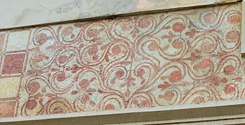 Geometric decoration elaborated with sgraffito in the interior zone
 -
 Coats of arms on the exterior Facade
 -
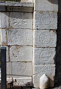 Marks of stonemasons
 -
 Niche with image of the Virgen del Pilar
 -
 Marks of the soldiers on duty
 -
 Exterior Facade with drawbridge


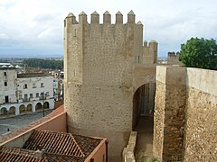
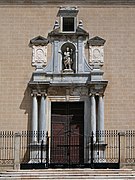
Palmas Gate


It has the number 13 in the "Plan of gates". It is located in front of the Palmas Bridge or Old Bridge, it is previous to the rest of the bastioned enclosure and is one of the most visited and studied for its beauty and state of conservation. It is located in the Plaza de los Reyes Católicos. It was built around the year 1460 and linked the historic center of Badajoz with the Old Bridge over the Guadiana River, a function it still performs although it is isolated as a historical architectural element and the connection with the bridge is made by two side streets that surround it. At first it was called "Puerta Nueva" (New Gate), but due to the construction of another gate in the 17th century in front of the current Autonomy Bridge, it was renamed Palmas Gate. The gate has two totally different facades –interior and exterior–.[56]
On the interior facade, the gate is flanked by two cylindrical merlon towers of circular section joined by a first lower body or access opening to the city that joins the two towers by means of a segmental arch with a slight archivolt. Both towers are surrounded at the top, below the battlements, by a decorative stone cordon, characteristic of the 16th century. The towers have in their upper part, at the height of their terraces, acroterion or plinths that support the ornaments. The second body, or upper body, has three successive semicircular arches, from one tower to another. The central arch is the largest and continues towards the interior in a slightly flared form and is decorated with coffers in whose center there is an image of "Our Lady of the Angels", made by Guillermo Silveira by order of the architect Francisco Vaca Morales, put in a Renaissance niche, that has a segmental arch and is finished off by a somewhat lowered pediment and in whose sides there are two symmetrical angels carved in relief. In front of these three arches there is a terrace as a chemin de ronde that serves as communication between both towers.[57][58]
The exterior Facade has two concentric semicircular arches. The interior part of the exterior arch is decorated with geometric hollows in the form of coffers. In the spandrels of the exterior arch it has two medallions, one on each side, of Charles V and Philip II. On the upper part of this Facade there is an inscription indicating that the door was built in 1551, during the reign of Philip II.[59]
The Palmas Gate, like other similar gates, has not only a defensive and passage control function but also a symbolic function as triumphal arches in honor of the sovereigns and kings of the time and, following the Renaissance style, imitates the triumphal arches of the Roman civilization. This door was used as a prison at the beginning of the 19th century. It was restored in 1960 by the architect, writer, essayist and art critic Francisco Vaca Morales. Palmas Bridge, the oldest bridge that crosses the Guadiana River through Badajoz, is closely related to the Palmas Gate and was built in 1596, during the reign of Philip II when Diego Hurtado de Mendoza was governor of Badajoz. In the bridge there is an inscription that indicates that it was finished in the mentioned year of 1596. However, some historians believe that the bridge was built at the same time as the gate, in 1460, and that it was later destroyed by a great flood in 1545.[60]
- Gallery
-
 Detail of chord, windows and gables
 -
 Inner arch with coffers
 -
 East tower with windows and chord
 -
 Coat of arms of Charles V on the exterior facade
 -
 Detail of the stone chord at the base of the towers
 -
 Virgin of the Angels on the inner facade of Palmas Gate


Pajaritos Gate


It has the number 14 in the "plan of gates". It is located under a tower in which is located the hermitage of Pajaritos that, although the exact date of its construction is not known, certain historians like Ayala and Rubio are inclined by the thesis that it could be of Islamic origin and indicate that it was of angled axis, that is to say, not straight, to make difficult the passage to the enemy and that it was not demolished when the Vauban defensive wall was raised.[61] Other historians indicate that it was built in the 16th century.[62]
This door was closed to vehicles and people for a long time and was even used as a sewer. It is now walled up. When the Vauban defensive wall was built, it was respected. Its structure was that of a corridor closed at the top by a barrel vault and topped at the ends with brick arches. The base of the vault along the entire length of the door is supported by granite ashlars. A small passageway served as access to an outbuilding that was probably intended to house the personnel of the gate's guard force. It is semi-buried although at the time of its construction it was at a higher level than the surrounding area so that it could exercise its functions as a gate.[62]
It is located near the "bridge of Autonomy", next to a traffic circle with sculptures of the heads of Luis Alvarez Lencero, Jesus Delgado Valhondo and Manuel Pacheco, all poets from Extremadura. The work is by the Badajoz sculptor Luis Martínez Giraldo.[63]
Next to the door is located the " Hermitage of Pajaritos" or of the orioles without knowing the date of its first construction. The popular tradition says that the name of the door is due to the fact that a painting by Luis de Morales called "La Virgen del pajarito", dated 1546, was exhibited there, currently preserved in the church of San Agustín of Madrid.[61] However, the reality seems to be that what existed in that door was a carving of the Virgin and Child, which is currently in the church of San Agustín in Badajoz.[64]
- Gallery
-
 Area of the defensive wall next to where the gate used to be
 -
 South-eastern view and view of the east defensive wall start
 -
 Western view of the hermitage
 -
 Curtain wall of the defensive wall where the Pajaritos Gate used to be
 -
 Decorative detail on the defensive wall in that area
 -
 Hermitage of Pajaritos. South-eastern view and start of defensive walls


San Vicente Gate


It is number 15 in the "plan of gates". San Vicente Gate is the only gate located outside the bastioned enclosure of the city of Badajoz, on the right bank of the Guadiana River, at the north end of the Palmas Bridge to the east of the "Hornabeque del Puente de Palmas" in the direction of the exit of the bridge.[65]
It was built around 1665 and was for more than two centuries one of the main access gates, especially because it allowed access to the city after crossing the Palmas Bridge that connects the two banks of the river. From there a covered way started that reached the fort of San Cristóbal, also in the right margin of the river, on a hill that dominates all this margin, along the old city of Badajoz.[65]
The mouth of the gate has a semi-elliptical section that extends inside through a passageway with a barrel vault section. Above the door there is a bartizan, that is to say, in cantilever and with a arrowslit floor to watch from the top the access to the door without having to lean out the defenders nor to expose themselves to the fire of the attackers. It has a square section, the only one of this geometric form that exists in the bastioned defensive system of Badajoz, and a terrace for access to it.[66]
It has a room that was used to house the "body of guard" that controlled access to the door, its morning opening and evening closing. Under the hornwork there is a moat that is crossed by means of a small bridge that has two columns of square section crowned by a ball. Both the bridge and the columns are made of masonry. When the deck of Palmas Bridge was extended over the hornwork at the end of the 19th century, the gate ceased to function.[67]
Pelambres Gate


It is numbered 16 in the Plan of Gates. The Pelambres Gate, also called "Portillo de Pelambres", has the first references of its existence in the early 16th century. Its name came from the tanners' guild that had been established in its vicinity and through it the waste of those settled in the "Curtidores" neighborhood was evacuated. The gate or shutter of this door was in front of the old street of the River, since it gave exit in front of the Guadiana and that happened to be called later "street of Joaquín Sama".[45] It is located between the Palmas Gate and the New Gate.[68]
According to the existing cartography and engravings, it must have been built between two not very large towers or in the middle of another much larger tower that remained until well into the 18th century. Its function was not only to give access to the river, but also to the nearby "Fuente de Mafra". After the opening of the "New Gate or Chariots Gate" and the "Palmas Gate", both very close to each other, this gate ceased to be useful as such and its mission was reduced to that of a sewer or spillway. The gate was completely closed when the "Batería del Redondo" was joined to the "Puerta de Palmas" by means of a defensive wall in 1886. It was filled with earth and stones on its inner side to form a street at a higher level that favored the defensive position of this area. At the present time only some vestiges of the lintel of the spillway can be seen on the outer face of the defensive wall and at ground level.[69]
New Gate


It is number 17 on the Plan of Gates. The New Gate is located in front of the current bridge of Autonomy and behind the palace of Godoy –formerly prison and today School of Business Sciences–, in a curtain wall of the defensive wall that went from the Pajaritos Gate to the Pelambres Gate. With the opening of this gate, the Pelambres Gate and Pajaritos were closed to traffic. It was a double doorway with a front drum and a place for the guard corps.[70][71]
It began to be built at the end of the 17th century according to the project designed by the military engineer Martín de Gabriel and was inaugurated in 1765. It was also known as Chariots Gate or Gate of the River although these denominations also fell on other doors of the walled enclosure that gave towards the Guadiana River. It had similar characteristics to the " Pilar Gate" since, although this door was demolished in 1962, according to the photos and descriptions that are conserved it was constituted by a segmental arch flanked by columns and finished off by a cornice. Like the Pilar Gate, it had a room that served as a "guardhouse" and an access ramp.[72] It is located in front of the bridge of Autonomy. At the beginning of the 21st century, its foundations, which had been buried since it was closed and then demolished, were discovered.[73]
Forts
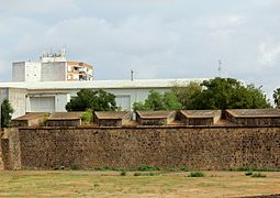
Fort of San Cristóbal


It is located on the right bank of the Guadiana River on the "Cerro de San Cristobal" which is surrounded by the EX-100 road. Access from this road is via a dirt road, recently paved, from the intersection formed by the streets of Inés Medrano Gil and Cardenal Cisneros. It was owned by the Ministry of Defense and was acquired by the Badajoz City Council in 1973.[74]
The fort of San Cristobal is the only one of the forts of the outer defensive constructions of the city that is preserved as it was built. In the place where it was erected, the Cerro de San Cristobal, was formerly the palace of the Dukes of Orinaza, and on this hill Ibn Marwan intended to found the city of Badajoz in the 9th century.[75]
This fort, erected during the Portuguese Restoration War, was one of the first works that enhanced the medieval defensive system of Badajoz and its construction began in 1642. It is the only exterior fort, of the many that were erected, that remains complete. It is rectangular in shape with two small bastions and two semi-bastions. The part of the defensive wall that joins the two bastions, which face north, is protected by a ravelin. The semi-baluartes, facing south, are joined by an embrasured gorge that is a narrowing in the triangular part of the ravelin itself in the place of contact with the defensive wall.[76][77]

It was equipped with embrasure for twelve cannons and capacity for about 300 riflemen. Its defensive walls are surrounded by a moat lined with stone from a nearby quarry. Over this moat sits another defensive wall as well as a "paseo de ronda".[78] In its reconstruction, its old defensive walls were reinforced with stone and provided with five outer crescents that served as advanced defenses and were distributed along the northern flank, which was not protected by the natural defense constituted by the river. The repair works continued throughout the war, being cemented into the old medieval wall. The gate of the fort and the San Vicente Gate, in the Hornabeque del Puente de Palmas, were connected by a covered way of which some sections are preserved.[79]
In its vicinities the Battle of the Gebora was fought on 19 February 1811 (name of the locality pertaining to the municipal term of Badajoz, and of the river of the same name), that finished with French victory on the Spanish army, and that figures in the Arc de Triomphe of Paris (with the names so much of Badajoz as of Gévora, doing allusion to its battles).[80] Inside it houses the Interpretation Center of the Fortifications of the Border. In January 2014 the restoration works were carried out as well as the tourist exploitation by awarding it to a private company.[81]
Fort of the Prince or of the Picuriña
It is located in the south-eastern part of the city, in the so-called " Park of the Picuriña", next to the street Marqués de Lombay. This fort was part of the outer defenses of the defensive system of the Badajoz bastioned enclosure. It was located in the northeast of the bastion of Trinidad, between the San Miguel mountain range and the Rivillas stream. Today only a few buildings remain in a semi-ruinous state.[82]
It was built in 1705 and was maintained until the 1970s when most of it was demolished and only a few buildings remained standing. It was a not very large but very strong fortification from the defensive point of view, exempt from the bastioned enclosure of the city. It was surrounded by a moat with only one access to the interior by means of a drawbridge. The communication with Badajoz was made by means of a covered way. The interior free space, which served as a parade ground, had a triangular plan. Along the coronation of the perimeter defensive wall it had twenty embrasure, which gives an idea of its defensive power. It had bartizan at the corners of the perimeter and embrasures in the lower part of the wall, consisting of openings larger than the hessian to be able to use firearms and artillery pieces to protect the moat in case it was taken by the enemy.[83]
Fort of Pardaleras


This fort was one of the walled redoubts that formed part of the outer defenses of the bastioned enclosure. Its location was very strategic since it could cover with its fire the Calamón stream as well as the hill of the Picuriña and the hill of the Wind by means of artillery fire. This hill is a hilltop of not much height but of a good strategic position that was very desired by the besiegers so most of the attacks on the city were made from that area. It was located in front of the Pilar Gate. In the 20th century the Preventive and Correctional Prison of Badajoz was built inside it and later the Museo Extremeño e Iberoamericano de Arte Contemporáneo, which preserves the characteristic cylindrical building of that prison, was built on this site. The photographs that appear in the description of the Pardaleras fort actually correspond to the Picuriña fort.[49]
Fort of Las Cuestas
In the northwest area of Badajoz and exempt from the city was the "Bastioned Fort of Las Cuestas" or line of fortification of Las Cuestas, north of the neighborhood of Santa Engracia. Its perimeter bordered the right bank of the Cuestas stream, an area known as "Cuesta Colorada". The fortification was limited by the BA-020 road to the Portuguese city of Campo Maior and by a drinking water treatment station at the opposite end. This fortification was attacked by the Portuguese army on several occasions as it was one of the first to oppose their advances towards Badajoz. After its use it was completely razed and no remains are preserved. The fort of Las Cuestas occupied the central part of this defensive line. It had a pentagonal plan and was equipped with bastions and semi-bastions at the corners. Only the remains of three forts and about 500 meters of trenches can be seen from the air.[84]
Hornwork of the Head of the Palmas Bridge


The hornwork is an external defense to the walled enclosures and consisted of a curtain wall that joined two semi-baluartes. In general they were built for the defense of river crossings. This hornwork is located on the right bank of the Guadiana River, next to the north end of the Palmas Bridge. Construction began in 1642, at the same time that the first modern defenses of Badajoz were being built.[85]
The "Head of the Bridge" was protected by a hornwork of this type and is composed of two semi-bastions joined by a curtain wall between them. The exit to the exterior was made going down the ramp that descends to the San Vicente Gate, not existing then the last arches of the bridge, which are of modern construction. It has a moat, a troop training square, crossings, foothills, a room for the guard corps and a room for the chief officer of the troops, as well as three bartizan and several embrasures for cannons.[86]
The hornwork has a single gate on its right flank, the San Vicente Gate, from where the roads to Alburquerque, Elvas, the Portuguese city of Campo Maior and the covered road that led to the fort of San Cristóbal used to leave. There are also some remains of the Rana fountain, built in the 18th century in the vicinity. The Palmas Bridge over the hornwork was built in 1868, lengthening the deck to give continuity to the bridge towards the street that linked the city with the new railroad station and thus facilitate the passage of vehicles.[85]
The fort of Cabeza del Puente and the fort of San Cristóbal had a great importance in the war that confronted Spain against Portugal since they were subjected to several attacks and sieges. During the Portuguese attack of 23 June 1658, which lasted all night, these troops managed to take the fort but it was recovered by the "Third of the Armada" although at the cost of many casualties, among them that of several captains and that of the Marquis of Lanzarote who was the governor of the square of Badajoz. In spite of them, the Portuguese troops did not cease in their determination since they regrouped in the area called "Vado del Moro", which they fortified and surrounded the city again.[86]
The route, which is not easy to follow intuitively because it has so many galleries, moats, etc., is done on the outside from the west flank to the east and then in the opposite direction with some deviations as indicated above.
- Gallery
-
 View from the outside of the west flank
 -
 View from the outside of the west flank
 -
 Acute-angled west flank curtain walls, moat and bartizan
 -
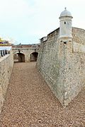 Westerly angled curtain walls, bartizan and moat
 -
 Curtain walls at a very acute angle, moat and bartizan and Palmas Bridge in the background
 -
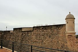 Northwestern curtain wall of the defensive wall with bartizan and embrasures
 -
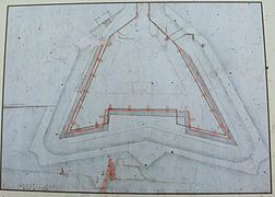 Badajoz hornwork project by Lorenzo Possi, ca. 1665
 -
 Modern crossing of the Palmas Bridge through the hornwork
 -
 Three angled curtain walls, bartizan, moat and embrasures to the northwest
 -
 West half with angled curtain walls, bartizan, moat and embrasures
 -
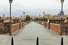 Palmas Bridge from the hornwork that is divided in two by the bridge
 -
 Eastern flank with bartizan, moat and San Vicente Gate
 -
 Exit from the San Vicente Gate to the covered road to the fort of San Critóbal
 -
 Eastern flank from Palmas Bridge and San Vicente Gate
 -
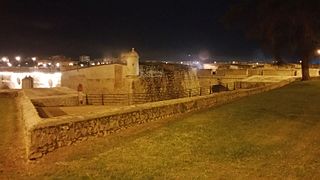 Night view of the right flank, to the north
 -
 Figurative scheme of the hornwork


Minor forts
In addition to the bastioned enclosure and the outer forts, a series of outer forts with less defensive capacity were also built, since they were defended only by moats and stakes. Erected in haste, very few had "covered passages", that is to say, communications by means of long trenches with sufficient depth to be protected from enemy fire when passing through them. In several cases the defenders were surrounded by the enemy, who took the fort and used it to tighten the siege. Among the various forts that were built were those of "Las Mayas", "Cerro del viento", "Vado del Mayordomo", "Vado del Moro", "San Miguel", "San Gabriel", "San Gaspar", "Telena" and several others.[87]
Ravelines

The ravelin –in old Spanish also known as rebellín– is a generally triangular fortification located exempt from the body of the main fortification and in front of it, usually on the other side of a moat to divide the attacking force and better cover the curtain walls by means of crossfire. Together with other elements, it is part of the so-called bastion fort, hence its etymology, since it comes from the Italian rivellino or revellino. Riflemen stand on benches that allow them to fire while their comrades crouch down to charge without exposing themselves to enemy fire. The side of the triangle semi-parallel to the curtain wall where the ravelin is arranged does not usually have defenses so that, in case it is taken by the enemy, they cannot chemin de ronde and make themselves strong in it.[88]
Ravelin of San Roque
It is located between Ricardo Carapeto Avenue and the Rivillas stream. The ravelin of San Roque defended the Puerta del Pilar, was built in the late 18th century and was linked by a covered road with the Fort of La Picuriña. The space between this enclave and the rest of the fortification could be flooded, so during the siege of 1812 a dam was built downstream of the Rivillas stream, raising the level of the stream a few meters. Its mission was to protect the area between the Bastion of San Pedro and the Bastion of La Trinidad.[89]
It has a triangular floor plan, almost equilateral, with the base in the area closest to the bastioned enclosure and the opposite angle pointing outward. The aforementioned base used to be unprotected so that, in case it was taken by the attacking forces, they could not use it as an attack post. On the other hand, this unprotection facilitated the retreat of the defending forces towards the city if the ravelin was taken by the attackers. The height of the ravelins was lower than that of the city defensive walls to attack them in case they were taken and they had a covered embankment and parapet. During the first years of the 21st century it has undergone numerous modifications although it has conserved many of its main elements. In the area closest to the Rivillas stream it has been fitted out as a park so that some of the original elements can be seen, but not in the opposite area where modern buildings constrict the ravelin, hiding it almost completely.[90]
Ravelin of the Auditorium


The ravelin of the Auditorium, so called lately for being next to an auditorium built outdoors, is located between the bastions of San José and San Vicente and its defensive function was to protect the curtain wall that joins both bastions. It is of little height and triangular plant, with a point of the triangle pointing towards the outside, from where the attacking forces came, since its mission is to divide them for a better defense of the corresponding bastion. The bastion of San Vicente has a postern on its left flank, protected by an orillon, as in other bastions already mentioned. The communication between the forces stationed in the ravelin and the interior of the city was done through this postern, which still exists and allowed the passage between the upper part of the bastion of San Vicente with the area where the ravelin is. Next to it is the Ricardo Carapeto Municipal Auditorium, hence its popular name.[91]
Ravelin of the Fort of San Cristóbal
It is located in the fort of San Cristobal. Like all the ravelins, it has a triangular plan with one vertex of the triangle pointing outwards, in this case towards the northwest, from where the attacks of the Portuguese army came from.[91]
Complex of tunnels and subway tunnels of the bastioned system
When the construction of the semi-bastion of San Antonio was carried out as part of the bastioned system of defensive walls and the Alpendiz Gate was closed, a series of tunnels and subway rooms were built in that area during the 17th century, known as the "Subterráneos de Calatrava" (Calatrava's Subterraneans). These were used to house troops and store war materials, thanks to the solidity of their walls and their bomb-proof vaults.[92]
Moats

In the bastioned enclosure of Badajoz, the moats surrounded the entire perimeter, as well as external works such as forts or ravelins. In some cases the moats were lined in such a way that the counterscarp was made of masonry, as was the defensive wall. At specific points, such as around the Bastion of La Trinidad or the ravelin of San Roque, there was the possibility of flooding the moat.[93]
In Badajoz there are still moats around almost all the preserved sections of the defensive wall. However, the counterscarp is only preserved around the bastions of San Pedro and Santa María, as well as in the hornwork, the fort of San Cristóbal and the ravelins of San Roque and Auditorio.[94]
The riflemen's galleries
A embrasured gallery for riflemen is a gallery located inside a bastion, usually on its flanks, with small arrowslit, divided into cells by transverse partitions, through which the soldiers can shoot and thus cover the moat. In the gallery there was a thick partition wall separating every three riflemen's posts so that, in the event of an artillery hit opening a gap in any area, the adjoining areas on both sides would not be affected. In the Badajoz bastioned enclosure riflemen's galleries were built in the last third of the 18th century according to the projects of the engineer Pedro Ruiz de Olano. Currently all but one of them are preserved.[40]
Covered roads, traverses, parade grounds and foothills
.jpg)
The covertway bordered all the moats, and also communicated the city with the forts and outer ravelins. Their function was to allow the movement of troops while under cover from enemy fire, and to allow firing from the inside while standing on the sidewalk and with the body protected by the parapet. The covered roads were hidden behind a foothills.[95]
The squares of arms also existed in several bastions, in the surroundings of the ravelin of San Roque and in the Auditorium as well as in the hornwork of the Head of the Bridge. The traverses, together with the stakes, protected the parade grounds. In Badajoz, traveses were only placed at the ends of the parade grounds, in the hornwork of the Head of the Bridge and in the covered road from the bridge of the Tenaza de La Trinidad to that of Merida.[86]
At present, most of the covered paths have disappeared, although they can still be seen in several places: from the bridge of the Tenaza de la Trinidad to the Merida Gate, in the fort of San Cristóbal, in the hornwork of the Palmas Bridge, in the surroundings of the ravelin of San Roque, in front of the bastion of San Vicente, in the ravelin of the Auditorium and in the surroundings of the moat that surrounds the Bastion of Santa María. The foothills that were in front of almost all the bastions have disappeared since, being a relatively flat surface, they have been used as lots for the modern constructions of the city.[96]
Mines, countermines and listening wells
The way to prevent the mines was to build counter mines, in which subway galleries were dug from the fortification, with their consequent stoves filled with gunpowder. In 1811, when the French took Badajoz, the first thing they did was to open counter mines between the bastions of Santiago and San Vicente. In Badajoz there must have been several, there is even a possible entrance to one of them, in the moat of the ravelin of Trinidad or San Roque.[97]
It has been identified in the fortifications of Badajoz a listening well in an angle, flanking the bastion of the Trinity, consisting of a passageway that starts from the chemin de ronde and descends to the entrance of the chamber, which served as a listening well. It had steps attached to the wall that allowed to go down to the lower part. It has been tentatively dated to the 1770s. The small storehouses or gunpowder stores could have acted at some point as listening wells.[98]
The longest walled enclosure in Spain and the largest citadel in Europe and the world
Studies carried out by historians and associations, such as the Civic Association City of Badajoz, have concluded that Badajoz has the longest walled enclosure of Spain, with a length of 6541 meters of defensive wall compared to 5000 meters of Pamplona, 3400 meters of Segovia, 2500 meters of Avila, 2200 meters of Lugo and 2000 meters of Melilla la Vieja in Melilla; being the second largest in the peninsula after the fortified complex of Elvas (which is considered the largest fortified complex in the world).[99] In the same way, it can be stated that the Arab citadel of Badajoz is not only the largest in Spain,[100] but also the largest in Europe and the largest in the world of its kind and time (8 hectares and more than 1300 meters of preserved defensive wall canvas); although its perimeter and area were even much larger with the so-called "Old Fence" (about 6000 meters of defensive wall and more than 50 hectares), of which important vestiges are still preserved, and which make it the largest of those built by the Arabs in the past.[101][102]
- Gallery
-
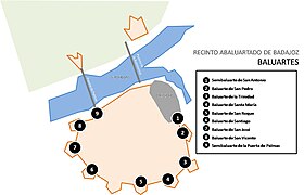 Map of bastions of the Badajoz bastioned enclosure
 -
 Map of gates of the Badajoz bastioned enclosure
 -
 Explanatory signs in the Alcazaba of Badajoz


Nearby buildings

- Alcazaba of Badajoz and Espantaperros Tower
- Plaza Alta, Badajoz and Jewish Quarter of Badajoz
- La Galera Gardens and Mudéjar Houses of Badajoz
- Palmas Bridge
- Cantillana Bridge
- Royal Bridge
- López de Ayala Theater
- Historic churches in Badajoz
- Mosque-cathedral of Badajoz
- Metropolitan Cathedral of Saint John the Baptist of Badajoz

Other nearby walled enclosures
See also
- Archdiocese of Merida–Badajoz
- Archaeological Museum of Badajoz
- Museo Extremeño e Iberoamericano de Arte Contemporáneo
- Badajoz
References
- ^ a b Navareño Mateo (1998, p. 52)
- ^ Araya & Rubio (1986, p. 34)
- ^ Araya & Rubio (1986, p. 35)
- ^ Cruz Villalón (1988, pp. 115–116)
- ^ "La Alcazaba de Badajoz" (PDF). Turismo de Badajoz.es (in Spanish). 2015. Archived from the original (PDF) on 21 December 2016. Retrieved 13 December 2016.
- ^ "Fortificación Abaluartada de Badajoz" (PDF). turismobadajoz.es (in Spanish). Archived from the original (PDF) on 21 December 2016. Retrieved 13 December 2016.
- ^ Campesino Fernández, Antonio José (1995). adajoz, pradigma de ciudad fronteriza (in Spanish) (15 ed.). Annales de Geografía de la Universidad Complutense. pp. 169–182.
- ^ Cruz Villalón (1988, p. 118)
- ^ Castro López, José (1873). La frontera hispano-portuguesa. Estudio descriptivo y militar (in Spanish). Madrid. pp. 57–59. Retrieved 23 October 2016.
{{cite book}}: CS1 maint: location missing publisher (link) - ^ a b c d e f g h Navareño Mateo (1998, p. 53)
- ^ a b Navareño Mateo (1998, pp. 52–53)
- ^ Cruz Villalón (1988, p. 115)
- ^ "Conde de Santiesteban. Carta a Pedro Coloma". Servicio Histórico Militar (in Spanish). 16: 46. 29 July 1643.
- ^ a b Cruz Villalón (1988, p. 117)
- ^ "Marqués de Torralbo. Carta a S.M. el Rey". Servicio Histórico Militar (in Spanish). 16: 42. 1641.
- ^ a b Araya & Rubio (1986, p. 47)
- ^ Navareño Mateo (1998, pp. 50–51)
- ^ Diccionario enciclopédico Popular Ilustrado Salvat (in Spanish). Salvat. 1907–1913. pp. Barcelona. OCLC 1193042. Retrieved 14 November 2016.
- ^ "Semibaluarte de San Antonio". monumentosdebadajoz.es (in Spanish). 14 June 2012. Retrieved 9 October 2016.
- ^ "Baluarte de San Pedro". monumentosdebadajoz.es (in Spanish). 14 June 2012. Retrieved 10 October 2016.
- ^ a b "Recinto abaluartado de Badajoz / Muralla Vauban de Badajoz". turismobadajoz.es (in Spanish). 2016. Archived from the original on 13 October 2016. Retrieved 17 November 2016.
- ^ "Recinto abaluartado". turismobadajoz.es (in Spanish). 9 January 2016. Archived from the original on 13 October 2016. Retrieved 12 October 2016.
- ^ "Departamento del Ejército de Tierra". Servicio histórico de Defensa (in Spanish). 1775.
- ^ "Baluarte de la Trinidad". monumentosdebadajoz.es (in Spanish). 14 June 2012. Retrieved 10 October 2016.
- ^ "La construcción del Baluarte de la Trinidad". Fortificación abaluartada de Badajoz (in Spanish). 2012. Retrieved 18 November 2016.
- ^ "Baluarte de la Trinidad". castillosnet (in Spanish). 21 December 2014. Retrieved 12 October 2016.
- ^ "Recinto abaluartado de Badajoz / Muralla Vauban de Badajoz". turismobadajoz.es (in Spanish). 19 January 2016. Archived from the original on 18 November 2016. Retrieved 17 November 2016.
- ^ a b "Baluarte de Santa María / La Laguna". CastillosNet (in Spanish). 21 December 2014. Retrieved 13 October 2016.
- ^ a b "Baluarte de Santa María". monumentosdebadajoz.es (in Spanish). 14 June 2012. Retrieved 13 October 2016.
- ^ a b c "Baluarte de San Roque". monumentosdebadajoz.es (in Spanish). 14 June 2012. Retrieved 14 October 2016.
- ^ "Baluarte de Santiago". .monumentosdebadajoz.es (in Spanish). 14 June 2012. Retrieved 28 November 2016.
- ^ Verdugo, José G. (3 February 2016). "El baluarte desaparecido de Badajoz". jgverdejo.blogspot.com/ (in Spanish). Retrieved 29 November 2016.
- ^ Lozano (1983, p. 119)
- ^ "Baluarte de Santiago". monumentosdebadajoz.es (in Spanish). 14 June 2012. Retrieved 29 November 2016.
- ^ "Recinto abaluartado de Badajoz / Muralla Vauban de Badajoz". turismobadajoz.es (in Spanish). 19 January 2016. Archived from the original on 19 November 2016. Retrieved 18 November 2016.
- ^ a b Lozano (1983, p. 122)
- ^ "Baluarte de Santiago". monumentosdebadajoz.es (in Spanish). 14 June 2012. Retrieved 21 November 2016.
- ^ "Baluarte de Santiago". .monumentosdebadajoz.es (in Spanish). 14 June 2011. Retrieved 29 November 2016.
- ^ "Baluarte de San José". monumentosdebadajoz.es (in Spanish). 14 June 2012. Retrieved 30 November 2016.
- ^ a b "Fortificación abaluartada de Badajoz". Cooperación transfronteriza España-Portugal (in Spanish): 22.
- ^ "Recinto abaluartado de Badajoz / Muralla Vauban de Badajoz". monumentosdebadajoz.es (in Spanish). 14 June 2012. Retrieved 7 December 2016.
- ^ "Recinto abaluartado de Badajoz / Muralla Vauban de Badajoz". monumentosdebadajoz.es (in Spanish). 14 June 2016. Retrieved 8 December 2016.
- ^ "Semi baluarte de Puerta de Palmas". castillosnet.org (in Spanish). 21 December 2014. Retrieved 7 December 2016.
- ^ Lozano (1983, p. 130)
- ^ a b c Araya & Rubio (1986, p. 43)
- ^ "Puertas conservadas en las murallas de la ciudad". monumentosdebadajoz.es (in Spanish). 2011. Retrieved 16 November 2016.
- ^ "Puerta de Mérida". castillosnet.org (in Spanish). 21 December 2014. Retrieved 7 October 2016.
- ^ "Puertas conservadas en las murallas de la ciudad". monumentosdebadajoz.es (in Spanish). 2011. Retrieved 7 October 2016.
- ^ a b Lozano (1983, p. 116)
- ^ a b "Puerta del Pilar". castillosnet.org (in Spanish). 21 December 2014. Retrieved 17 August 2016.
- ^ Lozano (1983, p. 115)
- ^ Araya & Rubio (1986, pp. 49–50)
- ^ a b "Puertas conservadas en las murallas de la ciudad". monumentosdebadajoz.es (in Spanish). Retrieved 17 August 2016.
- ^ "Puerta del Pilar". castillosnet.org (in Spanish). 21 December 2014. Retrieved 7 October 2016.
- ^ "Puertas conservadas en las murallas de la ciudad". monumentosdebadajoz.es (in Spanish). 14 June 2012. Retrieved 8 October 2016.
- ^ "March 2, 2016". castillosnet.org (in Spanish). Retrieved 5 October 2016.
- ^ Araya & Rubio (1986, pp. 43–45)
- ^ Navareño Mateo (1998, p. 50)
- ^ Araya & Rubio (1986, p. 45)
- ^ Araya & Rubio (1986, pp. 45–46)
- ^ a b Araya & Rubio (1986, p. 42)
- ^ a b "Puerta de Pajaritos". castillosnet.org (in Spanish). 21 December 2014. Retrieved 17 August 2016.
- ^ "Fuente de los Tres Poetas,Badajoz". extremadura.com (in Spanish). 15 November 2011. Retrieved 10 October 2016.
- ^ "Puerta de Pajaritos". monumentosdebadajoz.es (in Spanish). 14 June 2012. Retrieved 9 October 2016.
- ^ a b "Puerta de San Vicente". castillosnet.org (in Spanish). 13 December 2014. Retrieved 13 November 2016.
- ^ Navareño Mateo (1998, p. 51)
- ^ "Puerta de San Vicente". monumentosdebadajoz.es (in Spanish). 14 June 2012. Retrieved 17 August 2016.
- ^ "Puerta de Pelambres". castillosnet.org (in Spanish). 21 December 2014. Retrieved 17 August 2016.
- ^ "Puerta de Pelambres". monumentosdebadajoz.es (in Spanish). 14 June 2012. Retrieved 9 October 2016.
- ^ Araya & Rubio (1986, p. 50)
- ^ "Puerta Nueva". Fortificación abaluartada de Badajoz (in Spanish): 35. 2015.
- ^ "Puertas conservadas en las murallas de la ciudad". monumentosdebadajoz.es (in Spanish). 2011. Retrieved 8 October 2016.
- ^ "Puerta Nueva". castillosnet.org (in Spanish). 21 December 2014. Retrieved 17 August 2016.
- ^ "Recinto abaluartado de Badajoz/Muralla Vauban de Badajoz". monumentosdebadajoz.es (in Spanish). 14 June 2012. Retrieved 9 December 2016.
- ^ Pacheco Paniagua (1991, p. 48)
- ^ Navareño Mateo (1998, p. 315)
- ^ "Fuerte de San Cristóbal – Badajoz". losviajeros.com (in Spanish). 15 March 2014. Retrieved 6 December 2016.
- ^ "Recinto abaluartado de Badajoz/Muralla Vauban de Badajoz". monumentosdebadajoz.es (in Spanish). 14 June 2012. Retrieved 8 December 2016.
- ^ "Fuerte de San Cristóbal – Badajoz". losviajeros.com (in Spanish). 15 March 2014. Retrieved 8 December 2016.
- ^ Oman (1911, p. 51)
- ^ "Visita guiada al Fuerte de San Cristóbal en Badajoz". extremadura.com (in Spanish). 13 August 2016. Retrieved 8 December 2016.
- ^ Lozano (1983, p. 112)
- ^ "Recinto abaluartado de Badajoz / Muralla Vauban de Badajoz". monumentosdebadajoz.es (in Spanish). 14 June 2012. Retrieved 8 December 2016.
- ^ "Recinto abaluartado de Badajoz / Fuerte abaluartado de Las Cuestas". castillosnet.org (in Spanish). 17 August 2015. Retrieved 8 December 2016.
- ^ a b "Recinto abaluartado de Badajoz / Muralla Vauban de Badajoz". monumentosdebadajoz.es (in Spanish). 14 June 2012. Retrieved 9 December 2016.
- ^ a b c "Hornabeque de la Cabeza del Puente de Palmas". castillosnet.org (in Spanish). 10 February 2015. Retrieved 9 December 2016.
- ^ González Rodríguez (2010, p. 285)
- ^ Navareño Mateo (1998, pp. 312–317)
- ^ "Recinto abaluartado de Badajoz / Muralla Vauban de Badajoz". castillosnet.org (in Spanish). 10 February 2015. Retrieved 9 December 2016.
- ^ "Recinto abaluartado de Badajoz / Muralla Vauban de Badajoz". monumentosdebadajoz.es (in Spanish). 14 June 2012. Retrieved 9 December 2016.
- ^ a b "Recinto abaluartado de Badajoz / Muralla Vauban de Badajoz". monumentosdebadajoz.es (in Spanish). 14 June 2012. Retrieved 10 December 2016.
- ^ Altieri Sánchez, Juan; Sánchez Rubio, Carlos; Meléndez Teodoro, Álvaro (2013). En el Castillo de esta Ciudad a la Puerta del Alpendiz. Historia de una casa fuerte en la Alcazaba de Badajoz (in Spanish). Ayuntamiento de Badajoz.
- ^ "Baluarte de Santa María / La Laguna". castillosnet.org (in Spanish). 21 December 2014. Retrieved 12 December 2016.
- ^ Navareño Mateo (1998, p. 48)
- ^ Saint-Paul (1818, p. 34)
- ^ Teijeiro & Meléndez (2000, pp. 57–59)
- ^ Sánchez, Carlos (26 November 2014). "Pozo de escucha | 4 Gatos". 4gatos.es (in Spanish).
- ^ "La restauración del baluarte de la Trinidad recupera un pozo de escucha". hoy.es (in Spanish). 16 February 2017. Retrieved 7 April 2017.
- ^ Reigadas, Natalia (5 February 2017). "Badajoz tiene la muralla más larga". hoy.es (in Spanish). Retrieved 16 February 2017.
- ^ "La Alcazaba más grande de España". rtve.es (in Spanish). 21 June 2016. Retrieved 15 March 2017.
- ^ "La Alcazaba Árabe de Badajoz". descubrebadajoz.com (in Spanish). 21 June 2016. Archived from the original on 25 March 2017. Retrieved 15 March 2017.
- ^ Porras, Rebeca (24 January 2020). "Badajoz invita a conocer la alcazaba más grande de Europa". directoextremadura.com (in Spanish). Retrieved 25 January 2020.
Bibliography
- Araya, Carmen; Rubio, Fernando (1986). Guía artística de la Ciudad de Badajoz (PDF) (in Spanish). Badajoz: Diputación Provincial de Badajoz. ISBN 84-505-3676-6. Archived from the original (PDF) on 28 December 2009.
- Castro López, José (1873). La frontera hispano-portuguesa : estudio descriptivo y militar (in Spanish). Depósito de la Guerra.
- Cruz Villalón, María (1988). Las murallas de Badajoz en el siglo XVII (in Spanish) (8 ed.). Norba: revista de arte. pp. 115–142. ISSN 0213-2214.
- González Rodríguez, Alberto (2010). Historia de Badajoz (in Spanish). Ayuntamiento de Badajoz. ISBN 978-84-87762-22-2.
- Lozano, Matías (1983). Badajoz y sus murallas (in Spanish). Colegio Oficial de Arquitectos de Extremadura. ISBN 84-398-0736-8.
- Navareño Mateo, Antonio (1998). Castillos y Fortalezas en Extremadura (in Spanish). Badajoz: Hoy, Diario de Extremadura.
- Oman, Charles (1911). A History of the Peninsular War: Volume IV, December 1810 to December 1811. Greenhill Books. ISBN 1-85367-618-7.
- Pacheco Paniagua, Juan Antonio (1991). Extremadura en los geógrafos árabes (in Spanish). Badajoz. ISBN 978-84-779-6900-6.
{{cite book}}: CS1 maint: location missing publisher (link) - Saint-Paul, Noiet (1818). Elementos de fortificación (in Spanish). Madrid.
- Teijeiro, Javier; Meléndez, Álvaro (2000). La fortificación abaluartada de Badajoz en los siglos XVII y XVIII: apuntes históricos y urbanos (in Spanish). Badajoz. ISBN 84-607-0479-3.
{{cite book}}: CS1 maint: location missing publisher (link)
External links
- Fortifications of Badajoz, in Turismo de Badajoz, from YouTube channel. (in Spanish)
- Documentary: Bastioned fortifications of Badajoz (Subtitled ENG), in Turismo de Badajoz, from YouTube channel. (in Spanish)
- Badajoz, the largest walled city in Spain, in Asociación Cívica Ciudad de Badajoz, from YouTube channel. (in Spanish)
- Fortifications of Badajoz and Elvas, in Cross-Border Cooperation[permanent dead link]. (in Spanish)
- Route of the Fortifications, in Tourism of Badajoz. (in Spanish)
- Route of the Alcazaba, in Tourism of Badajoz. (in Spanish)
- Abaluartada Wall, in Turismo de Badajoz. (in Spanish)
- Fort of San Cristobal, in Badajoz Tourism. (in Spanish)
- Palm Bridge Hornabeque, in Tourism of Badajoz. (in Spanish)
- Route of Churches and Convents, in Tourism of Badajoz. (in Spanish)
- Route of Squares and Singular Buildings, in Tourism of Badajoz. (in Spanish)
- Fortifications of Badajoz, in Badajoz City Hall. (in Spanish)
- The largest Alcazaba in Europe is in Badajoz, on the YouTube channel of 48HorasMagazine (Promotional video of Fitur 2020 by the City of Badajoz). (in Spanish)
- Badajoz City Council at Fitur 2020, official presentation of the largest Alcazaba in Europe and the most extensive system of fortifications in Spain. (in Spanish)
- Bird's eye view of the Alcazaba of Badajoz, on Nois78's YouTube channel. (in Spanish)
- CS1 Spanish-language sources (es)
- CS1 maint: location missing publisher
- Use dmy dates from July 2023
- Articles with short description
- Short description matches Wikidata
- Wikipedia articles needing copy edit from June 2023
- All articles needing copy edit
- Commons category link is on Wikidata
- All articles with dead external links
- Articles with dead external links from September 2023
- Articles with permanently dead external links
- Buildings and structures in the Province of Badajoz
- Bien de Interés Cultural landmarks in the Province of Badajoz
- 17th-century architecture in Spain