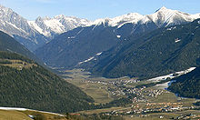
Antholzer Tal
Jump to navigation
Jump to search
46°50′49″N 12°05′41″E / 46.846808°N 12.094746°E


Antholzer Tal (Italian: valle di Anterselva) is a side valley of the Upper Puster Valley in Rasen-Antholz municipality, South Tyrol, Italy.
It is part of Rieserferner-Ahrn Nature Park[1][2] and named after the village of Antholz.
settlements
Several villages and hamlets are situated here, the lowest being Niederrasen at the entrance, followed towards the end are Oberrasen, Antholz Niedertal, Antholz Mittertal and Antholz Obertal.
See also
- Antholzer See (3rd largest in South Tyrol)
- Valleys of South Tyrol
External links
![]() Media related to Antholzer Tal at Wikimedia Commons
Media related to Antholzer Tal at Wikimedia Commons
![]() Media related to Antholzer Tal at Wikimedia Commons
Media related to Antholzer Tal at Wikimedia Commons
Sources
- Abteilung Forstwirtschaft der Autonomen Provinz Bozen – Südtirol (publ.): Waldtypisierung Südtirol. Band 2: Waldgruppen, Naturräume, p. 268, Bozen 2010
References
- ^ One of a kind: the Rieserferner-Ahrn Nature Park
- ^ SPA, Südtiroler Informatik AG | Informatica Alto Adige. "The Park's habitats | Nature Parks | Autonomous Province of Bozen/Bolzano - South Tyrol". Nature Parks. Retrieved 2023-11-22.
Categories:
- Pages using gadget WikiMiniAtlas
- Articles with short description
- Short description is different from Wikidata
- Orphaned articles from November 2023
- All orphaned articles
- Coordinates on Wikidata
- Articles containing Italian-language text
- Commons link from Wikidata
- Commons category link from Wikidata
- Valleys of South Tyrol
- Rieserferner-Ahrn Nature Park
- All stub articles
- Trentino-Alto Adige/Südtirol geography stubs