Forchtenstein
Forchtenstein | |
|---|---|
.JPG) | |
 Coat of arms | |
 Forchtenstein Location within Burgenland  Forchtenstein Location within Austria | |
| Coordinates: 47°43′N 16°20′E / 47.717°N 16.333°E | |
| Country | |
| State | Burgenland |
| District | Mattersburg |
| Government | |
| • Mayor | Friederike Reismüller |
| Area | |
| • Total | 16.59 km2 (6.41 sq mi) |
| Elevation | 343 m (1,125 ft) |
| Population (2018-01-01)[2] | |
| • Total | 2,796 |
| • Density | 170/km2 (440/sq mi) |
| Time zone | UTC+1 (CET) |
| • Summer (DST) | UTC+2 (CEST) |
| Postal code | 7212 |
| Website | www.gemeindeforchtenstein.at |
Forchtenstein (Hungarian: Fraknóváralja or Fraknókő, Croatian: Fortnavski grad; until 1972, Forchtenau, Fraknó, Fortnava) is a town in the district of Mattersburg in the Austrian state of Burgenland. It is the location of Forchtenstein Castle, one of the many palaces of the famous Esterházy family.
It consists of two subdivisions (Katastralgemeinden) which were formerly separate towns: Forchtenau (Hungarian: Fraknó) and Neustift an der Rosalia (Hungarian: Újtelek).
Population
| Year | Pop. | ±% |
|---|---|---|
| 1869 | 1,685 | — |
| 1880 | 1,732 | +2.8% |
| 1890 | 1,816 | +4.8% |
| 1900 | 2,054 | +13.1% |
| 1910 | 2,158 | +5.1% |
| 1923 | 2,127 | −1.4% |
| 1934 | 2,213 | +4.0% |
| 1939 | 2,223 | +0.5% |
| 1951 | 2,184 | −1.8% |
| 1961 | 2,363 | +8.2% |
| 1971 | 2,502 | +5.9% |
| 1981 | 2,557 | +2.2% |
| 1991 | 2,678 | +4.7% |
| 2001 | 2,832 | +5.8% |
| 2011 | 2,845 | +0.5% |
The castle gained a nickname as the "Castle of Fear". The castle has one red and one black tower. The castle boasted many torture chambers including one called the Pit of Oblivion, a deep pit where torture victims would be strung upside down and deprived of food and water until they died. The Pit of Oblivion is located in the black tower. Although many of the rooms are now available to the public either for rental or visitation, the treasure room of the castle still remains private and inaccessible.
Gallery
-
 Sculpture at Esterházy Castle
 -
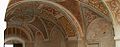
 At Esterházy Castle
 -
 At Esterházy Castle
 -
 Aerial photograph of the castle


References
- ^ "Dauersiedlungsraum der Gemeinden Politischen Bezirke und Bundesländer - Gebietsstand 1.1.2018". Statistics Austria. Retrieved 10 March 2019.
- ^ "Einwohnerzahl 1.1.2018 nach Gemeinden mit Status, Gebietsstand 1.1.2018". Statistics Austria. Retrieved 9 March 2019.
External links
| International | |
|---|---|
| National | |
This Hungarian history article is a stub. You can help Wikipedia by expanding it. |
This Burgenland location article is a stub. You can help Wikipedia by expanding it. |
- Articles with short description
- Short description is different from Wikidata
- Coordinates on Wikidata
- Articles containing Hungarian-language text
- Articles containing Croatian-language text
- Articles with VIAF identifiers
- Articles with GND identifiers
- Articles with NKC identifiers
- Cities and towns in Mattersburg District
- Croatian communities in Burgenland
- Esterházy family
- All stub articles
- Hungarian history stubs
- Burgenland geography stubs