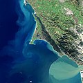
File:Where Tectonic Plates Go for a Swim.jpg
Jump to navigation
Jump to search

Size of this preview: 600 × 600 pixels. Other resolutions: 240 × 240 pixels | 480 × 480 pixels | 768 × 768 pixels | 1,024 × 1,024 pixels | 2,048 × 2,048 pixels | 4,823 × 4,823 pixels.
Original file (4,823 × 4,823 pixels, file size: 10.36 MB, MIME type: image/jpeg)
File history
Click on a date/time to view the file as it appeared at that time.
| Date/Time | Thumbnail | Dimensions | User | Comment | |
|---|---|---|---|---|---|
| current | 04:09, 11 February 2021 |  | 4,823 × 4,823 (10.36 MB) | commons>StellarHalo | {{Information |Description=There is an obvious difference between the dark green coniferous forests that dominate the western shore of Tomales Bay and the lighter green grasslands on the east side. But the differences between the two shores run much deeper than the vegetation. Tomales Bay lies about 50 kilometers (30 miles) northwest of San Francisco, along the edges of two tectonic plates that are grinding past each other. The boundary between them is the San Andreas Fault, the famous rift... |
File usage
There are no pages that use this file.