File:Wahlkreise Weimar.png
Jump to navigation
Jump to search
Size of this preview: 777 × 600 pixels. Other resolutions: 311 × 240 pixels | 622 × 480 pixels | 969 × 748 pixels.
Original file (969 × 748 pixels, file size: 148 KB, MIME type: image/png)
Summary
| Description |
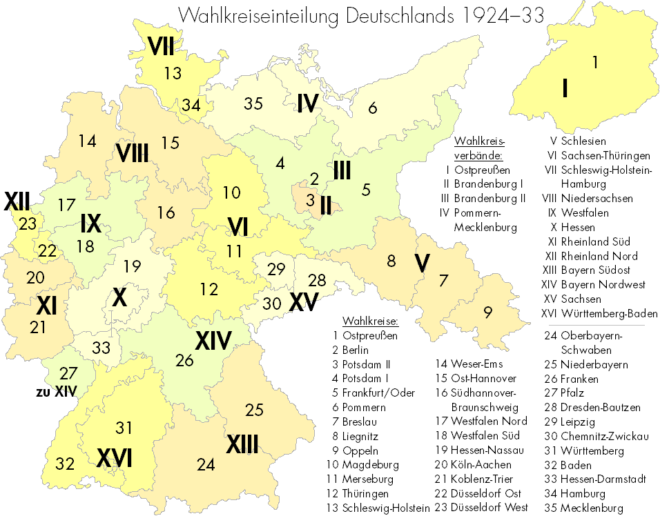
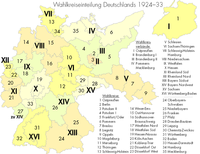
Deutsch: Wahlkreiseinteilung Deutschlands in der Weimarer Republik. Die Karte zeigt die offizielle Nummerierung und Namensgebung, wie sie bei den Reichstagswahlen von 1924 bis 1933 üblich war. English: Map showing the 35 constituencies of Germany between 1924 and 1933. |
| Date | 21. September 2007 / September 21, 2007 |
| Source | Own work |
| Author | http://commons.wikimedia.org/wiki/User:Korny78 |
Licensing
I, the copyright holder of this work, hereby publish it under the following license:
This file is licensed under the Creative Commons Attribution-Share Alike 2.5 Generic license.
- You are free:
- to share – to copy, distribute and transmit the work
- to remix – to adapt the work
- Under the following conditions:
- attribution – You must give appropriate credit, provide a link to the license, and indicate if changes were made. You may do so in any reasonable manner, but not in any way that suggests the licensor endorses you or your use.
- share alike – If you remix, transform, or build upon the material, you must distribute your contributions under the same or compatible license as the original.
File history
Click on a date/time to view the file as it appeared at that time.
| Date/Time | Thumbnail | Dimensions | User | Comment | |
|---|---|---|---|---|---|
| current | 15:40, 28 September 2007 | | 969 × 748 (148 KB) | commons>Korny78 | {{Information |Description= Wahlkreiseinteilung Deutschlands in der Weimarer Republik. Die Karte zeigt die offizielle Nummerierung und Namensgebung, wie sie bei den Reichstagswahlen von 1924 bis 1933 üblich war. / Map showing the 35 constituencies of Ger |
File usage
There are no pages that use this file.