File:Vimy Ridge 1917-barrage map.jpg
Jump to navigation
Jump to search

Size of this preview: 442 × 599 pixels. Other resolutions: 177 × 240 pixels | 354 × 480 pixels | 566 × 768 pixels | 755 × 1,024 pixels | 1,963 × 2,662 pixels.
Original file (1,963 × 2,662 pixels, file size: 922 KB, MIME type: image/jpeg)
File history
Click on a date/time to view the file as it appeared at that time.
| Date/Time | Thumbnail | Dimensions | User | Comment | |
|---|---|---|---|---|---|
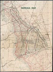
| current | 18:42, 5 January 2008 | | 1,963 × 2,662 (922 KB) | commons>Labattblueboy | {{Information |Description= High Resolution Barrage Map [Showing Boundaries and Objectives for Assault on Vimy Ridge, Scale [1:10,000] |Source= National Archives of Canada (NMC-111113) |Date= Produced 1917 |Author= 1st Field Survey Company, Royal Engineer |
File usage
There are no pages that use this file.