File:Van Diemen's Land 1852.jpg
Jump to navigation
Jump to search

Size of this preview: 600 × 600 pixels. Other resolutions: 240 × 240 pixels | 480 × 480 pixels | 768 × 768 pixels | 1,200 × 1,200 pixels.
Original file (1,200 × 1,200 pixels, file size: 211 KB, MIME type: image/jpeg)
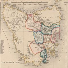
Map of Van Diemen's Land 1852, showing two types of subdivisions. Old public domain map from NLA, located here
This image or other work is of Australian origin and is now in the public domain because its term of copyright has expired. According to the Australian Copyright Council (ACC), ACC Information Sheet G023v19 (Duration of copyright) (January 2019).1
When using this template, please provide information of where the image was first published and who created it. |
 | |||||||||||||||||||
File history
Click on a date/time to view the file as it appeared at that time.
| Date/Time | Thumbnail | Dimensions | User | Comment | |
|---|---|---|---|---|---|
| current | 14:47, 18 March 2007 | | 1,200 × 1,200 (211 KB) | commons>Roke~commonswiki | Map of Van Diemen's Land 1852, showing two types of subdivisions. Old public domain map from NLA, located [http://nla.gov.au/nla.map-nk11155-2 here] {{PD-Australia}} Category:Maps of Tasmania |
File usage
There are no pages that use this file.