File:Usgs map azimuthal equidistant.PNG
Jump to navigation
Jump to search
No higher resolution available.
Usgs_map_azimuthal_equidistant.PNG (487 × 162 pixels, file size: 46 KB, MIME type: image/png)
File history
Click on a date/time to view the file as it appeared at that time.
| Date/Time | Thumbnail | Dimensions | User | Comment | |
|---|---|---|---|---|---|
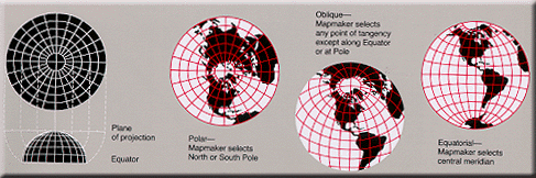
| current | 14:25, 17 February 2005 | 487 × 162 (46 KB) | commons>Quadell | World map projection ([http://erg.usgs.gov/isb/pubs/MapProjections/projections.html source)]{{PD-USGov-USGS}}Category:World mapsCategory:Map projectionsCategory:Map diagrams |
File usage
There are no pages that use this file.