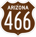
File:US 466 Arizona 1956 East.svg

From WikiProjectMed
Jump to navigation Jump to search

Original file(SVG file, nominally 372 × 384 pixels, file size: 20 KB)

This file is from a shared repository and may be used by other projects. The description on its file description page there is shown below.

Summary

Description
English: This image is a representation of a 1950's technicolor U.S. Route shield used by Arizona. Each color meant a different direction. Brown meant East, Green meant South, Orange meant North and Blue meant West. Arizona replaced the signs with traditional Black and White shields in the late 50's early 60's.
Date
Source File:US XX Arizona 1954 East.svg
Author Matthew Anderson (Base template modified from original File:US blank (1961).svg by Fredddie)

Licensing

Public domain This file is in the public domain because it comes from the Manual on Uniform Traffic Control Devices, which states specifically on page I-1 that:
Any traffic control device design or application provision contained in this Manual shall be considered to be in the public domain. Traffic control devices contained in this Manual shall not be protected by a patent, trademark, or copyright, except for the Interstate Shield and any other items owned by FHWA.

Captions

Add a one-line explanation of what this file represents

Items portrayed in this file

depicts

23 March 2015

image/svg+xml

File history

Click on a date/time to view the file as it appeared at that time.

Date/TimeThumbnailDimensionsUserComment
current06:37, 28 June 2023Thumbnail for version as of 06:37, 28 June 2023372 × 384 (20 KB)commons>MatthewAnderson707Changed shield shape, now based on 1961 spec for higher accuracy.

There are no pages that use this file.

Metadata