File:UP region map.gif
Jump to navigation
Jump to search

Size of this preview: 800 × 564 pixels. Other resolutions: 320 × 226 pixels | 640 × 452 pixels | 1,024 × 722 pixels | 1,175 × 829 pixels.
Original file (1,175 × 829 pixels, file size: 124 KB, MIME type: image/gif)
File history
Click on a date/time to view the file as it appeared at that time.
| Date/Time | Thumbnail | Dimensions | User | Comment | |
|---|---|---|---|---|---|
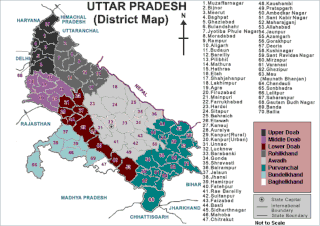
| current | 06:53, 26 October 2010 | | 1,175 × 829 (124 KB) | commons>File Upload Bot (Magnus Manske) | {{BotMoveToCommons|en.wikipedia|year={{subst:CURRENTYEAR}}|month={{subst:CURRENTMONTHNAME}}|day={{subst:CURRENTDAY}}}} {{Information |Description={{en|This map depicts regions of en:Uttar Pradesh: # Upper Doab # [[:en:Doab|Middle Doab] |
File usage
There are no pages that use this file.