File:Thermopylae & Artemisium campaign map.png
Jump to navigation
Jump to search

Size of this preview: 493 × 600 pixels. Other resolutions: 197 × 240 pixels | 394 × 480 pixels | 822 × 1,000 pixels.
Original file (822 × 1,000 pixels, file size: 1.04 MB, MIME type: image/png)
File history
Click on a date/time to view the file as it appeared at that time.
| Date/Time | Thumbnail | Dimensions | User | Comment | |
|---|---|---|---|---|---|
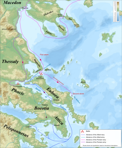
| current | 07:53, 24 April 2009 | | 822 × 1,000 (1.04 MB) | commons>MinisterForBadTimes | {{Information Campaign map for the Battles of Thermopylae & Artemisium (480 BC), based on the description of Herodotus. Imposed on a Bathymetic/Topographical map of the Aegean Sea. *UTM projection; WGS84 datum ; shaded relief<br/> *Scales:<br/> **Topograp |
File usage
There are no pages that use this file.