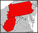
File:Synod of the Trinity map - border.svg

From WikiProjectMed
Jump to navigation Jump to search

Original file(SVG file, nominally 159 × 137 pixels, file size: 208 KB)

This file is from a shared repository and may be used by other projects. The description on its file description page there is shown below.

Description
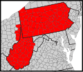
English: Map of counties in the Synod of the Trinity.
Date (UTC)
Source
Author
Other versions

Derivative works of this file:


This is a retouched picture, which means that it has been digitally altered from its original version. Modifications: Modify map. The original can be viewed here: Usa counties large.svg. Modifications made by GrapedApe.


Public domain
This image or file is a work of a United States Census Bureau employee, taken or made as part of that person's official duties. As a work of the U.S. federal government, the image is in the public domain.

English  español  日本語  македонски  മലയാളം  português do Brasil  русский  українська  עברית  +/−


This W3C-unspecified vector image was created with Inkscape .

Original upload log

This image is a derivative work of the following images:

  • File:Usa_counties_large.svg licensed with PD-USGov-DOC-Census
    • 2010-02-07T00:27:18Z Abe.suleiman 990x627 (1727952 Bytes) {{Information |Description={{en|This is a map of the [[United States]] showing the borders of states and counties in high detail.}} |Source=*[[:File:USA_Counties.svg|]] |Date=2010-02-07 00:19 (UTC) |Author=*[[:File:USA_Counti

Uploaded with derivativeFX

Captions

Add a one-line explanation of what this file represents

Items portrayed in this file

depicts

20 April 2011

File history

Click on a date/time to view the file as it appeared at that time.

Date/TimeThumbnailDimensionsUserComment
current23:12, 20 April 2011Thumbnail for version as of 23:12, 20 April 2011159 × 137 (208 KB)commons>GrapedApefix a different border problem

There are no pages that use this file.