File:Sediment Sloshes in Solway Firth.jpg
Jump to navigation
Jump to search

Size of this preview: 800 × 590 pixels. Other resolutions: 320 × 236 pixels | 640 × 472 pixels | 1,024 × 756 pixels | 1,280 × 945 pixels | 2,560 × 1,889 pixels | 3,860 × 2,849 pixels.
Original file (3,860 × 2,849 pixels, file size: 2.53 MB, MIME type: image/jpeg)
File history
Click on a date/time to view the file as it appeared at that time.
| Date/Time | Thumbnail | Dimensions | User | Comment | |
|---|---|---|---|---|---|
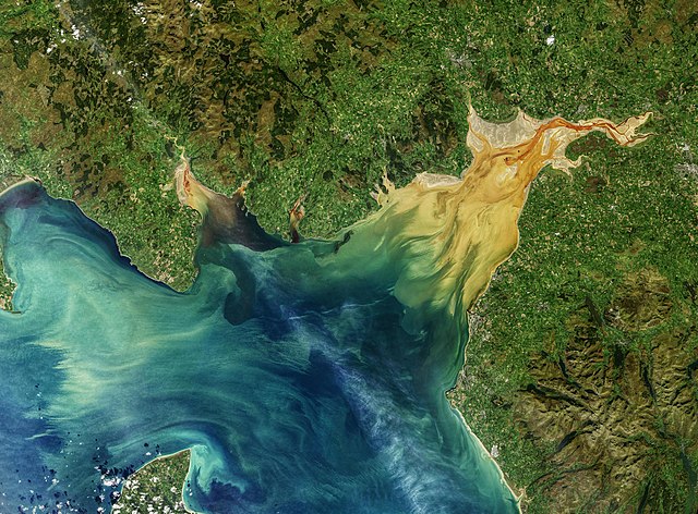
| current | 17:41, 1 February 2021 | | 3,860 × 2,849 (2.53 MB) | commons>StellarHalo | {{Information |Description=Fjords and funnel-shaped bays and inlets are often scenes of dramatic tidal changes; the Bay of Fundy is perhaps the world’s most spectacular example. This sloshing of water into and out of basins can produce visible surges of sediment and floating debris, turbulent mixing of fresh and salty waters, and sometimes distinct lines between different water masses. That was the case in October 2019 when the Operational Land Imager on the Landsat 8 satellite captured the... |
File usage
There are no pages that use this file.