File:Roman Fort and the Antonine Wall - geograph.org.uk - 1449013.jpg
Jump to navigation
Jump to search
No higher resolution available.
Roman_Fort_and_the_Antonine_Wall_-_geograph.org.uk_-_1449013.jpg (640 × 480 pixels, file size: 55 KB, MIME type: image/jpeg)
Summary
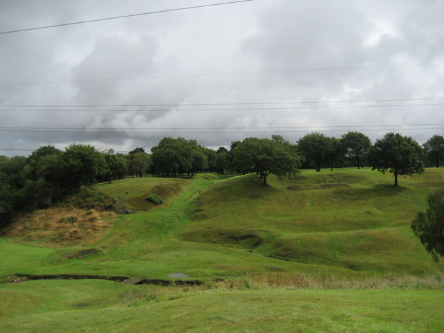
| Description |
English: Roman Fort and the Antonine Wall The ditch, clearly seen in a lighter shade of green, marks the course of the Antonine Wall - the most north westerly frontier achieved by the Roman Empire. I believe it was only in use for little over 20 years. To the right are ridges and mounds that indicate the position of the Roman Fort at Rough Castle - the whole scene reminds me of a golf course. |
| Date | |
| Source | From geograph.org.uk |
| Author | Chris Heaton |
| Attribution (required by the license) | Chris Heaton / Roman Fort and the Antonine Wall / |
| Camera location | | View this and other nearby images on: OpenStreetMap |
|---|
_heading:67.00&language=en)
| Object location | | View this and other nearby images on: OpenStreetMap |
|---|
_heading:67.00&language=en)
Licensing

|
This image was taken from the Geograph project collection. See this photograph's page on the Geograph website for the photographer's contact details. The copyright on this image is owned by Chris Heaton and is licensed for reuse under the Creative Commons Attribution-ShareAlike 2.0 license.
|
This file is licensed under the Creative Commons Attribution-Share Alike 2.0 Generic license.
Attribution: Chris Heaton
- You are free:
- to share – to copy, distribute and transmit the work
- to remix – to adapt the work
- Under the following conditions:
- attribution – You must give appropriate credit, provide a link to the license, and indicate if changes were made. You may do so in any reasonable manner, but not in any way that suggests the licensor endorses you or your use.
- share alike – If you remix, transform, or build upon the material, you must distribute your contributions under the same or compatible license as the original.
File history
Click on a date/time to view the file as it appeared at that time.
| Date/Time | Thumbnail | Dimensions | User | Comment | |
|---|---|---|---|---|---|
| current | 02:54, 2 March 2011 | | 640 × 480 (55 KB) | commons>GeographBot | == {{int:filedesc}} == {{Information |description={{en|1=Roman Fort and the Antonine Wall The ditch, clearly seen in a lighter shade of green, marks the course of the Antonine Wall - the most north westerly frontier achieved by the Roman Empire. I believ |
File usage
There are no pages that use this file.