File:Rade de Lorient topographic map-fr.svg
Jump to navigation
Jump to search

Size of this PNG preview of this SVG file: 605 × 599 pixels. Other resolutions: 242 × 240 pixels | 485 × 480 pixels | 775 × 768 pixels | 1,034 × 1,024 pixels | 2,067 × 2,048 pixels | 3,539 × 3,506 pixels.
Original file (SVG file, nominally 3,539 × 3,506 pixels, file size: 1.34 MB)
Summary
| Camera location | | View this and other nearby images on: OpenStreetMap |
|---|
| Description |
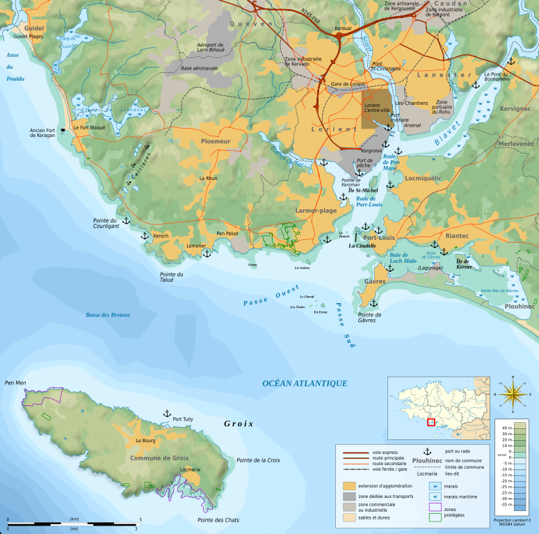
Français : Carte topographique et administrative en français de la rade de Lorient, montrant la ville de Lorient, l'île de Groix et, entre les deux, l'entrée de la rade avec les passes Ouest et Sud. Les deux passes sont séparées par des bas-fonds rocheux des Courreaux de Groix. La carte montre aussi la Petite Mer de Gâvres, l'embouchure du Blavet et l'aéroport de Lann Bihoué.
Deutsch: Topographische Karte / Straßenkarte der Île de Groix und der Stadt Lorient (Bretagne, in Französische.
日本語: フランス語で表示したロリアンの地形図。
|
||
| Date | (UTC) | ||
| Source |
Création personnelle ;
données de la carte © les contributeurs d'OpenStreetMap, CC-BY-SA Openstreetmap via Cloudmade ;
|
||
| Author | © Bourrichon (talk) - fr:Bourrichon | ||
| Permission (Reusing this file) |
|
||
| Other versions |
Add-your-version : Template:Other versions/Rade de Lorient map Template:Other versions/Rade de Lorient map |
Licensing
I, the copyright holder of this work, hereby publish it under the following licenses:

|
Permission is granted to copy, distribute and/or modify this document under the terms of the GNU Free Documentation License, Version 1.2 or any later version published by the Free Software Foundation; with no Invariant Sections, no Front-Cover Texts, and no Back-Cover Texts. A copy of the license is included in the section entitled GNU Free Documentation License. |
This file is licensed under the Creative Commons Attribution-Share Alike 3.0 Unported, 2.5 Generic, 2.0 Generic and 1.0 Generic license.
- You are free:
- to share – to copy, distribute and transmit the work
- to remix – to adapt the work
- Under the following conditions:
- attribution – You must give appropriate credit, provide a link to the license, and indicate if changes were made. You may do so in any reasonable manner, but not in any way that suggests the licensor endorses you or your use.
- share alike – If you remix, transform, or build upon the material, you must distribute your contributions under the same or compatible license as the original.
You may select the license of your choice.

|
This SVG file contains embedded text that can be translated into your language, using any capable SVG editor, text editor or the SVG Translate tool. For more information see: About translating SVG files. |
This W3C-unspecified vector image was created with Inkscape .
File history
Click on a date/time to view the file as it appeared at that time.
| Date/Time | Thumbnail | Dimensions | User | Comment | |
|---|---|---|---|---|---|
| current | 17:31, 9 February 2013 | | 3,539 × 3,506 (1.34 MB) | commons>Bourrichon |
File usage
There are no pages that use this file.