File:Plaque, Drones River - geograph.org.uk - 1422094.jpg
Jump to navigation
Jump to search
No higher resolution available.
Plaque,_Drones_River_-_geograph.org.uk_-_1422094.jpg (640 × 479 pixels, file size: 65 KB, MIME type: image/jpeg)
Summary
| Description |
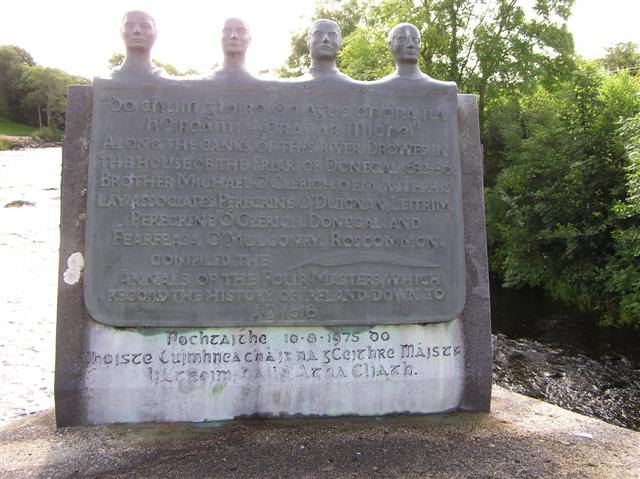
English: Plaque, Drones River It is located on the bridge here. It is in Irish and English, the latter reads, "Along the banks of this river, Drowes, in the house of the Friars of Donegal 1632-36, brother Michael Clérich, O.F.M. with his lay associates Peregrine O'Duignan, Leitrim, Peregrine Ó Clérich, Donegal and Fearfeasa O'Mulconry, Roscommon complied the Annals of the Four Masters which record the history of Ireland down to AD1616" |
| Date | |
| Source | From geograph.org.uk |
| Author | Kenneth Allen |
| Attribution (required by the license) | Kenneth Allen / Plaque, Drones River / |
| Camera location | | View this and other nearby images on: OpenStreetMap |
|---|
_heading:135.00&language=en)
| Object location | | View this and other nearby images on: OpenStreetMap |
|---|
_heading:135.00&language=en)
Licensing

|
This image was taken from the Geograph project collection. See this photograph's page on the Geograph website for the photographer's contact details. The copyright on this image is owned by Kenneth Allen and is licensed for reuse under the Creative Commons Attribution-ShareAlike 2.0 license.
|
This file is licensed under the Creative Commons Attribution-Share Alike 2.0 Generic license.
Attribution: Kenneth Allen
- You are free:
- to share – to copy, distribute and transmit the work
- to remix – to adapt the work
- Under the following conditions:
- attribution – You must give appropriate credit, provide a link to the license, and indicate if changes were made. You may do so in any reasonable manner, but not in any way that suggests the licensor endorses you or your use.
- share alike – If you remix, transform, or build upon the material, you must distribute your contributions under the same or compatible license as the original.
File history
Click on a date/time to view the file as it appeared at that time.
| Date/Time | Thumbnail | Dimensions | User | Comment | |
|---|---|---|---|---|---|
| current | 20:09, 1 March 2011 | | 640 × 479 (65 KB) | commons>GeographBot | == {{int:filedesc}} == {{Information |description={{en|1=Plaque, Drones River It is located on the bridge here [1422080]. It is in Irish and English, the latter reads, "Along the banks of this river, Drowes, in the house of the Friars of Donegal 1632- |
File usage
There are no pages that use this file.