File:Pakistan-Waziristan-Map.png
Jump to navigation
Jump to search

Size of this preview: 606 × 599 pixels. Other resolutions: 243 × 240 pixels | 486 × 480 pixels | 700 × 692 pixels.
Original file (700 × 692 pixels, file size: 96 KB, MIME type: image/png)
Summary
| Description |
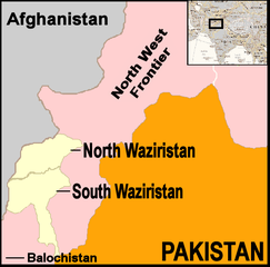
English: Map showing location of North and South Waziristan in northern Pakistan and bordering on Afghanistan |
||||
| Date | |||||
| Source | drawn by uploader using Jasc Paint Shop, using as insert map a reference map in Public Domain from the United States Central Intelligence Agency | ||||
| Author | Thaddeus P. Bejnar | ||||
| Permission (Reusing this file) |
Public Domain, I (Thaddeus P. Bejnar) hereby release this work to the Public Domain | ||||
| Other versions |
|


.svg)


.svg)


.svg)


_Territory_Change_2014-2016.gif)

_(within_Northern_Syria).svg)


.png)
.svg)


_map.png)
.svg)


.svg)


Licensing
| I, the copyright holder of this work, release this work into the public domain. This applies worldwide. In some countries this may not be legally possible; if so: I grant anyone the right to use this work for any purpose, without any conditions, unless such conditions are required by law. |
File history
Click on a date/time to view the file as it appeared at that time.
| Date/Time | Thumbnail | Dimensions | User | Comment | |
|---|---|---|---|---|---|
| current | 21:59, 7 November 2006 | | 700 × 692 (96 KB) | commons>Bejnar | {{Information |Description=Map showing location of North and South Waziristan in northern Pakistan and bordering on Afghanistan |Source=drawn by uploader using Jasc Paint Shop |Date=7 November 2006 |Author=Thaddeus P. Bejnar |Permission=Public Domain, I ( |
File usage
There are no pages that use this file.