File:Paintsville City Hall.jpg
Jump to navigation
Jump to search

Size of this preview: 800 × 532 pixels. Other resolutions: 320 × 213 pixels | 640 × 426 pixels | 1,024 × 681 pixels | 1,280 × 851 pixels | 2,560 × 1,702 pixels | 6,016 × 4,000 pixels.
Original file (6,016 × 4,000 pixels, file size: 6.35 MB, MIME type: image/jpeg)
|
This is an image of a place or building that is listed on the National Register of Historic Places in the United States of America. Its reference number is 88003158. |
| Camera location | | View this and other nearby images on: OpenStreetMap |
|---|
| Description |
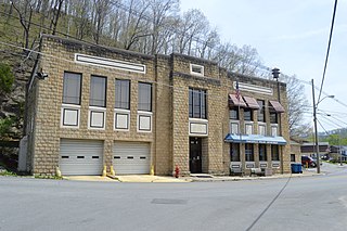
English: Front and northern end of the Paintsville City Hall, located at the junction of Euclid Avenue (Kentucky Route 40) with Second and Margaret Heights streets in Paintsville, Kentucky, United States. Built in 1939, it is listed on the National Register of Historic Places. |
||
| Date | Taken on 21 April 2014 | ||
| Source | Own work | ||
| Author | Nyttend | ||
| Permission (Reusing this file) |
|
File history
Click on a date/time to view the file as it appeared at that time.
| Date/Time | Thumbnail | Dimensions | User | Comment | |
|---|---|---|---|---|---|
| current | 04:53, 5 May 2014 | | 6,016 × 4,000 (6.35 MB) | commons>Nyttend | {{NRHP|88003158}} {{Location|37|48|55|N|82|48|9|W}} {{Information |Description={{en|Front and northern end of the {{w|Paintsville City Hall}}, located at the junction of Euclid Avenue ({{w|Kentucky Route 40}}) with Second and Margaret Heights streets i... |
File usage
There are no pages that use this file.